Albion geodata
Albion (Illinois) is a seat of a second-order administrative division; located in United States in America/Chicago (GMT-5) time zone. With population of 1,932 people, there are 12143 cities with bigger population in this country. Compared to other cities in United States, 59.5% of cities are located further ↑North; 53.1% of cities are located further →East and 59% of cities have higher elevation than Albion. Note1


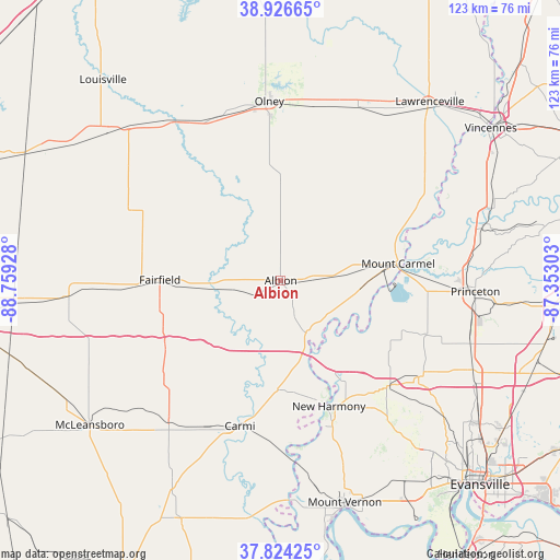
Albion GPS coordinates[2]
38° 22' 39.18" North, 88° 3' 22.14" West
| Map corner | latitude | longitude |
|---|---|---|
| Upper-left | 38.92665°, | -88.75928° |
| Center: | 38.37755°, | -88.05615° |
| Lower-right: | 37.82425°, | -87.35303° |
| Map W x H: | 122.6×122.6 km | = 76.2×76.2mi |
| max Lat: | 71.29058° ⇑59.5% North |
| Albion: | 38.37755° |
| min Lat: | ⇓40.5% South 19.06759° |
| min Long | Albion | max Long |
| -171.73463° | -88.05615° | -66.98998° |
| W 46.9%⇐ | ⇒53.1% E |
Elevation
Elevation of Albion is 160 m = 525 ft, and this is 134.8 m = 442 ft below average elevation for this country.
| Max E: |
3189 m = 10463 ft | 59% |
| Avg. | 294.8 m = 967 ft | |
| Albion | 160 m = 525 ft | |
Min E: |
-60 m = -197 ft | 41% |
See also: United States elevation on elevation.city.
Geographical zone
Albion is located in North temperate zone (between Tropic of Cancer and the Arctic Circle). Distance of this Northern Tropic circle is 1661.3 km =1032.3 mi to South.| Distance of | km | miles | from Albion |
|---|---|---|---|
| North Pole | 5739.9 | 3566.6 | to North |
| Arctic Circle | 3134 | 1947.4 | to North |
| Tropic Cancer | 1661.3 | 1032.3 | to South |
| Equator | 4267.2 | 2651.5 | to South |


Nearby cities:
15 places around Albion: (largest is in red/bold)
• Carmi
33.1 km =20.6 mi,  195°
195°
• Cisne
36.6 km =22.7 mi,  294°
294°
• Crossville
24 km =14.9 mi,  181°
181°
• Cynthiana
36.8 km =22.9 mi,  124°
124°
• Enfield
39.5 km =24.5 mi,  218°
218°
• Fairfield
26.5 km =16.5 mi,  270°
270°
• Grayville
14.4 km =8.9 mi,  157°
157°
• Mount Carmel
26 km =16.2 mi,  81°
81°
• New Harmony
29.5 km =18.3 mi, 159°
• Noble
38.4 km =23.9 mi,  337°
337°
• Olney
39.4 km =24.5 mi,  356°
356°
• Owensville
34.2 km =21.3 mi,  110°
110°
• Patoka
41.1 km =25.5 mi,  85°
85°
• Poseyville
33.2 km =20.6 mi,  134°
134°
• West Salem
16.6 km =10.3 mi,  15°
15°
Sources, notices
• [Note1] Compared only with cities in United States existing in our database
• [Src1] Map data: © OpenStreetMap contributors (CC-BY-SA)
• [Src2] Other city data from geonames.org with taken over terms of usage.
• [Src3] Geographical zone / Annual Mean Temperature by Robert A. Rohde @ Wikipedia
