Mount Carmel geodata
Mount Carmel (Illinois) is a seat of a second-order administrative division; located in United States in America/Chicago (GMT-5) time zone. With population of 7,027 people, there are 5799 cities with bigger population in this country. Compared to other cities in United States, 59.3% of cities are located further ↑North; 51.7% of cities are located further →East and 63.3% of cities have higher elevation than Mount Carmel. Note1


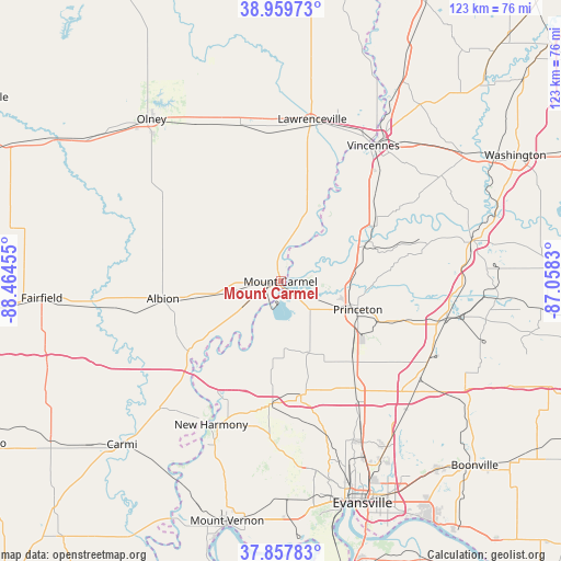
Mount Carmel GPS coordinates[2]
38° 24' 39.168" North, 87° 45' 41.112" West
| Map corner | latitude | longitude |
|---|---|---|
| Upper-left | 38.95973°, | -88.46455° |
| Center: | 38.41088°, | -87.76142° |
| Lower-right: | 37.85783°, | -87.0583° |
| Map W x H: | 122.5×122.5 km | = 76.1×76.1mi |
| max Lat: | 71.29058° ⇑59.3% North |
| Mount Carmel: | 38.41088° |
| min Lat: | ⇓40.7% South 19.06759° |
| min Long | Mount Carmel | max Long |
| -171.73463° | -87.76142° | -66.98998° |
| W 48.3%⇐ | ⇒51.7% E |
Elevation
Elevation of Mount Carmel is 137 m = 449 ft, and this is 157.8 m = 518 ft below average elevation for this country.
| Max E: |
3189 m = 10463 ft | 63.3% |
| Avg. | 294.8 m = 967 ft | |
| Mount Carmel | 137 m = 449 ft | |
Min E: |
-60 m = -197 ft | 36.7% |
See also: United States elevation on elevation.city.
Geographical zone
Mount Carmel is located in North temperate zone (between Tropic of Cancer and the Arctic Circle). Distance of this Northern Tropic circle is 1665 km =1034.6 mi to South.| Distance of | km | miles | from Mount Carmel |
|---|---|---|---|
| North Pole | 5736.2 | 3564.3 | to North |
| Arctic Circle | 3130.3 | 1945.1 | to North |
| Tropic Cancer | 1665 | 1034.6 | to South |
| Equator | 4270.9 | 2653.8 | to South |


Nearby cities:
15 places around Mount Carmel: (largest is in red/bold)
• Albion
26 km =16.2 mi,  261°
261°
• Bridgeport
32.8 km =20.4 mi,  0°
0°
• Cynthiana
25.2 km =15.7 mi,  169°
169°
• Fort Branch
23.7 km =14.7 mi,  138°
138°
• Grayville
26.5 km =16.5 mi,  229°
229°
• Haubstadt
28.1 km =17.5 mi, 144°
• New Harmony
34.7 km =21.6 mi,  205°
205°
• Owensville
16.7 km =10.4 mi,  157°
157°
• Patoka
15.3 km =9.5 mi,  91°
91°
• Poseyville
26.8 km =16.7 mi,  184°
184°
• Princeton
18 km =11.2 mi,  110°
110°
• Saint Francisville
22.4 km =13.9 mi,  26°
26°
• Sumner
35.1 km =21.8 mi,  345°
345°
• Vincennes
35.9 km =22.3 mi, 34°
• West Salem
24.5 km =15.2 mi,  299°
299°
Sources, notices
• [Note1] Compared only with cities in United States existing in our database
• [Src1] Map data: © OpenStreetMap contributors (CC-BY-SA)
• [Src2] Other city data from geonames.org with taken over terms of usage.
• [Src3] Geographical zone / Annual Mean Temperature by Robert A. Rohde @ Wikipedia
