Olney geodata
Olney (Illinois) is a seat of a second-order administrative division; located in United States in America/Chicago (GMT-5) time zone. With population of 9,005 people, there are 4803 cities with bigger population in this country. Compared to other cities in United States, 57.1% of cities are located further ↑North; 53.3% of cities are located further →East and 61.9% of cities have higher elevation than Olney. Note1


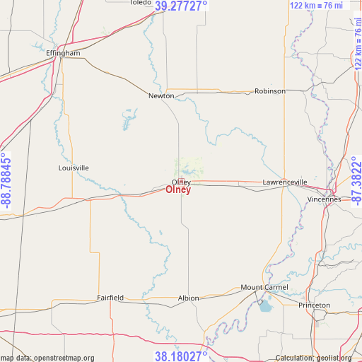
Olney GPS coordinates[2]
38° 43' 51.168" North, 88° 5' 7.152" West
| Map corner | latitude | longitude |
|---|---|---|
| Upper-left | 39.27727°, | -88.78845° |
| Center: | 38.73088°, | -88.08532° |
| Lower-right: | 38.18027°, | -87.3822° |
| Map W x H: | 122×122 km | = 75.8×75.8mi |
| max Lat: | 71.29058° ⇑57.1% North |
| Olney: | 38.73088° |
| min Lat: | ⇓42.9% South 19.06759° |
| min Long | Olney | max Long |
| -171.73463° | -88.08532° | -66.98998° |
| W 46.7%⇐ | ⇒53.3% E |
Elevation
Elevation of Olney is 145 m = 476 ft, and this is 149.8 m = 491 ft below average elevation for this country.
| Max E: |
3189 m = 10463 ft | 61.9% |
| Avg. | 294.8 m = 967 ft | |
| Olney | 145 m = 476 ft | |
Min E: |
-60 m = -197 ft | 38.1% |
See also: United States elevation on elevation.city.
Geographical zone
Olney is located in North temperate zone (between Tropic of Cancer and the Arctic Circle). Distance of this Northern Tropic circle is 1700.6 km =1056.7 mi to South.| Distance of | km | miles | from Olney |
|---|---|---|---|
| North Pole | 5700.6 | 3542.2 | to North |
| Arctic Circle | 3094.7 | 1923 | to North |
| Tropic Cancer | 1700.6 | 1056.7 | to South |
| Equator | 4306.5 | 2675.9 | to South |


Nearby cities:
15 places around Olney: (largest is in red/bold)
• Albion
39.4 km =24.5 mi,  176°
176°
• Bridgeport
28.4 km =17.6 mi,  95°
95°
• Cisne
38.8 km =24.1 mi,  231°
231°
• Clay City
23.8 km =14.8 mi,  258°
258°
• Dieterich
44.8 km =27.8 mi,  325°
325°
• Flora
35.4 km =22 mi, 258°
• Lawrenceville
35 km =21.7 mi,  90°
90°
• Louisville
36.5 km =22.7 mi,  277°
277°
• Newton
29.7 km =18.5 mi,  346°
346°
• Noble
12.6 km =7.8 mi,  252°
252°
• Oblong
33.8 km =21 mi,  26°
26°
• Robinson
42.8 km =26.6 mi,  44°
44°
• Saint Francisville
41.1 km =25.5 mi,  112°
112°
• Sumner
19.5 km =12.1 mi, 94°
• West Salem
24.4 km =15.2 mi,  163°
163°
Sources, notices
• [Note1] Compared only with cities in United States existing in our database
• [Src1] Map data: © OpenStreetMap contributors (CC-BY-SA)
• [Src2] Other city data from geonames.org with taken over terms of usage.
• [Src3] Geographical zone / Annual Mean Temperature by Robert A. Rohde @ Wikipedia
