Arthur geodata
Arthur (Illinois) is a populated place; located in United States in America/Chicago (GMT-5) time zone. With population of 2,288 people, there are 11112 cities with bigger population in this country. Compared to other cities in United States, 50.8% of cities are located further ↓South; 54.7% of cities are located further →East and 51% of cities have lower elevation than Arthur. Note1


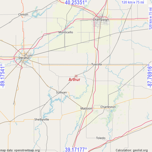
Arthur GPS coordinates[2]
39° 42' 53.136" North, 88° 28' 20.208" West
| Map corner | latitude | longitude |
|---|---|---|
| Upper-left | 40.25351°, | -89.17541° |
| Center: | 39.71476°, | -88.47228° |
| Lower-right: | 39.17177°, | -87.76916° |
| Map W x H: | 120.3×120.3 km | = 74.8×74.8mi |
| max Lat: | 71.29058° ⇑49.2% North |
| Arthur: | 39.71476° |
| min Lat: | ⇓50.8% South 19.06759° |
| min Long | Arthur | max Long |
| -171.73463° | -88.47228° | -66.98998° |
| W 45.3%⇐ | ⇒54.7% E |
Elevation
Elevation of Arthur is 202 m = 663 ft, and this is 92.8 m = 304 ft below average elevation for this country.
| Max E: |
3189 m = 10463 ft | 49% |
| Avg. | 294.8 m = 967 ft | |
| Arthur | 202 m = 663 ft | |
Min E: |
-60 m = -197 ft | 51% |
See also: United States elevation on elevation.city.
Geographical zone
Arthur is located in North temperate zone (between Tropic of Cancer and the Arctic Circle). Distance of this Northern Tropic circle is 1809.9 km =1124.6 mi to South.| Distance of | km | miles | from Arthur |
|---|---|---|---|
| North Pole | 5591.2 | 3474.2 | to North |
| Arctic Circle | 2985.3 | 1855 | to North |
| Tropic Cancer | 1809.9 | 1124.6 | to South |
| Equator | 4415.9 | 2743.9 | to South |


Nearby cities:
15 places around Arthur: (largest is in red/bold)
• Arcola
14.6 km =9.1 mi,  103°
103°
• Atwood
9.5 km =5.9 mi,  5°
5°
• Bement
24.6 km =15.3 mi,  339°
339°
• Bethany
24 km =14.9 mi,  251°
251°
• Cerro Gordo
29.3 km =18.2 mi,  311°
311°
• Chapin
31.7 km =19.7 mi, 305°
• Dalton City
28.4 km =17.6 mi,  269°
269°
• Findlay
32.2 km =20 mi,  228°
228°
• Lovington
13.7 km =8.5 mi, 270°
• Mattoon
27.1 km =16.8 mi,  161°
161°
• Pesotum
28 km =17.4 mi,  37°
37°
• Sullivan
17.3 km =10.7 mi,  222°
222°
• Tuscola
18.7 km =11.6 mi,  59°
59°
• Villa Grove
31.2 km =19.4 mi, 58°
• Windsor
32.2 km =20 mi,  199°
199°
Sources, notices
• [Note1] Compared only with cities in United States existing in our database
• [Src1] Map data: © OpenStreetMap contributors (CC-BY-SA)
• [Src2] Other city data from geonames.org with taken over terms of usage.
• [Src3] Geographical zone / Annual Mean Temperature by Robert A. Rohde @ Wikipedia
