Benton geodata
Benton (Illinois) is a seat of a second-order administrative division; located in United States in America/Chicago (GMT-5) time zone. With population of 7,041 people, there are 5790 cities with bigger population in this country. Compared to other cities in United States, 61.6% of cities are located further ↑North; 55.9% of cities are located further →East and 61.9% of cities have higher elevation than Benton. Note1


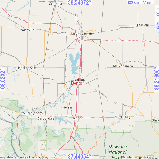
Benton GPS coordinates[2]
37° 59' 48.192" North, 88° 55' 12.252" West
| Map corner | latitude | longitude |
|---|---|---|
| Upper-left | 38.54872°, | -89.6232° |
| Center: | 37.99672°, | -88.92007° |
| Lower-right: | 37.44054°, | -88.21695° |
| Map W x H: | 123.2×123.2 km | = 76.6×76.6mi |
| max Lat: | 71.29058° ⇑61.6% North |
| Benton: | 37.99672° |
| min Lat: | ⇓38.4% South 19.06759° |
| min Long | Benton | max Long |
| -171.73463° | -88.92007° | -66.98998° |
| W 44.1%⇐ | ⇒55.9% E |
Elevation
Elevation of Benton is 145 m = 476 ft, and this is 149.8 m = 491 ft below average elevation for this country.
| Max E: |
3189 m = 10463 ft | 61.9% |
| Avg. | 294.8 m = 967 ft | |
| Benton | 145 m = 476 ft | |
Min E: |
-60 m = -197 ft | 38.1% |
See also: United States elevation on elevation.city.
Geographical zone
Benton is located in North temperate zone (between Tropic of Cancer and the Arctic Circle). Distance of this Northern Tropic circle is 1618.9 km =1005.9 mi to South.| Distance of | km | miles | from Benton |
|---|---|---|---|
| North Pole | 5782.2 | 3592.9 | to North |
| Arctic Circle | 3176.3 | 1973.7 | to North |
| Tropic Cancer | 1618.9 | 1005.9 | to South |
| Equator | 4224.8 | 2625.2 | to South |


Nearby cities:
15 places around Benton: (largest is in red/bold)
• Christopher
12 km =7.5 mi,  257°
257°
• Coello
12.9 km =8 mi,  268°
268°
• Energy
26.5 km =16.5 mi,  200°
200°
• Herrin
23.5 km =14.6 mi, 203°
• Hurst
26.7 km =16.6 mi,  227°
227°
• Ina
17.2 km =10.7 mi,  4°
4°
• Johnston City
19.6 km =12.2 mi,  181°
181°
• Pittsburg
25.2 km =15.7 mi,  165°
165°
• Royalton
21.6 km =13.4 mi, 232°
• Sesser
15.5 km =9.6 mi,  312°
312°
• Thompsonville
16.4 km =10.2 mi,  122°
122°
• Valier
10.9 km =6.8 mi,  280°
280°
• West City
1.4 km =0.9 mi, 256°
• West Frankfort
11 km =6.8 mi,  185°
185°
• Zeigler
15.8 km =9.8 mi, 226°
Sources, notices
• [Note1] Compared only with cities in United States existing in our database
• [Src1] Map data: © OpenStreetMap contributors (CC-BY-SA)
• [Src2] Other city data from geonames.org with taken over terms of usage.
• [Src3] Geographical zone / Annual Mean Temperature by Robert A. Rohde @ Wikipedia
