Sesser geodata
Sesser (Illinois) is a populated place; located in United States in America/Chicago (GMT-5) time zone. With population of 1,906 people, there are 12210 cities with bigger population in this country. Compared to other cities in United States, 61.1% of cities are located further ↑North; 56.3% of cities are located further →East and 61.5% of cities have higher elevation than Sesser. Note1


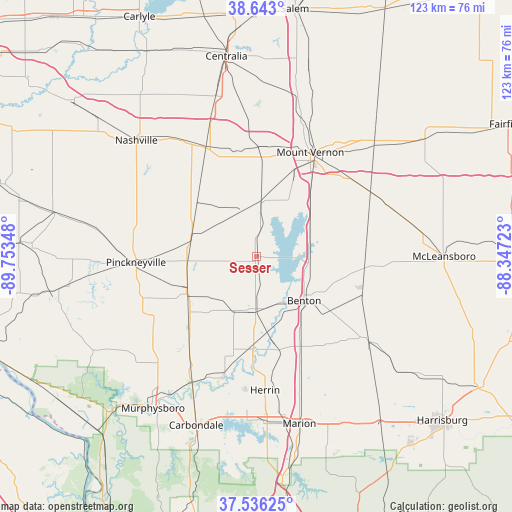
Sesser GPS coordinates[2]
38° 5' 30.192" North, 89° 3' 1.26" West
| Map corner | latitude | longitude |
|---|---|---|
| Upper-left | 38.643°, | -89.75348° |
| Center: | 38.09172°, | -89.05035° |
| Lower-right: | 37.53625°, | -88.34723° |
| Map W x H: | 123.1×123.1 km | = 76.5×76.5mi |
| max Lat: | 71.29058° ⇑61.1% North |
| Sesser: | 38.09172° |
| min Lat: | ⇓38.9% South 19.06759° |
| min Long | Sesser | max Long |
| -171.73463° | -89.05035° | -66.98998° |
| W 43.7%⇐ | ⇒56.3% E |
Elevation
Elevation of Sesser is 147 m = 482 ft, and this is 147.8 m = 485 ft below average elevation for this country.
| Max E: |
3189 m = 10463 ft | 61.5% |
| Avg. | 294.8 m = 967 ft | |
| Sesser | 147 m = 482 ft | |
Min E: |
-60 m = -197 ft | 38.5% |
See also: United States elevation on elevation.city.
Geographical zone
Sesser is located in North temperate zone (between Tropic of Cancer and the Arctic Circle). Distance of this Northern Tropic circle is 1629.5 km =1012.5 mi to South.| Distance of | km | miles | from Sesser |
|---|---|---|---|
| North Pole | 5771.7 | 3586.4 | to North |
| Arctic Circle | 3165.8 | 1967.1 | to North |
| Tropic Cancer | 1629.5 | 1012.5 | to South |
| Equator | 4235.4 | 2631.8 | to South |


Nearby cities:
15 places around Sesser: (largest is in red/bold)
• Benton
15.5 km =9.6 mi,  132°
132°
• Christopher
13.3 km =8.3 mi,  181°
181°
• Coello
10.9 km =6.8 mi,  187°
187°
• Du Quoin
18.6 km =11.6 mi,  241°
241°
• Elkville
25.9 km =16.1 mi,  218°
218°
• Ina
14.4 km =8.9 mi,  62°
62°
• Mount Vernon
28.2 km =17.5 mi,  27°
27°
• Pinckneyville
29.1 km =18.1 mi,  267°
267°
• Royalton
24.5 km =15.2 mi, 193°
• Tamaroa
16.5 km =10.3 mi,  288°
288°
• Valier
8.5 km =5.3 mi, 175°
• West City
14.8 km =9.2 mi,  137°
137°
• West Frankfort
23.9 km =14.9 mi,  154°
154°
• Woodlawn
26.5 km =16.5 mi,  3°
3°
• Zeigler
21.4 km =13.3 mi, 180°
Sources, notices
• [Note1] Compared only with cities in United States existing in our database
• [Src1] Map data: © OpenStreetMap contributors (CC-BY-SA)
• [Src2] Other city data from geonames.org with taken over terms of usage.
• [Src3] Geographical zone / Annual Mean Temperature by Robert A. Rohde @ Wikipedia
