Brighton geodata
Brighton (Illinois) is a populated place; located in United States in America/Chicago (GMT-5) time zone. With population of 2,198 people, there are 11347 cities with bigger population in this country. Compared to other cities in United States, 54.4% of cities are located further ↑North; 59.4% of cities are located further →East and 51.5% of cities have lower elevation than Brighton. Note1
Administrative division(s):
- Level 1: Illinois
- Level 2: Macoupin County
- Level 3: Township of Brighton


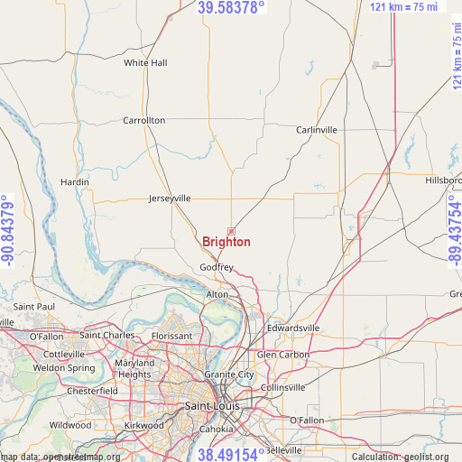
Brighton GPS coordinates[2]
39° 2' 23.172" North, 90° 8' 26.376" West
| Map corner | latitude | longitude |
|---|---|---|
| Upper-left | 39.58378°, | -90.84379° |
| Center: | 39.03977°, | -90.14066° |
| Lower-right: | 38.49154°, | -89.43754° |
| Map W x H: | 121.4×121.4 km | = 75.4×75.4mi |
| max Lat: | 71.29058° ⇑54.4% North |
| Brighton: | 39.03977° |
| min Lat: | ⇓45.6% South 19.06759° |
| min Long | Brighton | max Long |
| -171.73463° | -90.14066° | -66.98998° |
| W 40.6%⇐ | ⇒59.4% E |
Elevation
Elevation of Brighton is 204 m = 669 ft, and this is 90.8 m = 298 ft below average elevation for this country.
| Max E: |
3189 m = 10463 ft | 48.5% |
| Avg. | 294.8 m = 967 ft | |
| Brighton | 204 m = 669 ft | |
Min E: |
-60 m = -197 ft | 51.5% |
See also: United States elevation on elevation.city.
Geographical zone
Brighton is located in North temperate zone (between Tropic of Cancer and the Arctic Circle). Distance of this Northern Tropic circle is 1734.9 km =1078 mi to South.| Distance of | km | miles | from Brighton |
|---|---|---|---|
| North Pole | 5666.2 | 3520.8 | to North |
| Arctic Circle | 3060.4 | 1901.6 | to North |
| Tropic Cancer | 1734.9 | 1078 | to South |
| Equator | 4340.8 | 2697.2 | to South |


Nearby cities:
15 places around Brighton: (largest is in red/bold)
• Alton
17 km =10.6 mi,  192°
192°
• Bethalto
16.9 km =10.5 mi,  149°
149°
• Bunker Hill
16.3 km =10.1 mi,  88°
88°
• East Alton
17.9 km =11.1 mi,  171°
171°
• Elsah
21.1 km =13.1 mi,  243°
243°
• Godfrey
10.2 km =6.3 mi,  203°
203°
• Hartford
23.3 km =14.5 mi, 170°
• Holiday Shores
21.7 km =13.5 mi,  127°
127°
• Jerseyville
18.5 km =11.5 mi,  298°
298°
• Rosewood Heights
17.6 km =10.9 mi,  164°
164°
• Roxana
22 km =13.7 mi, 165°
• Shipman
12 km =7.5 mi,  43°
43°
• Upper Alton
14.3 km =8.9 mi,  183°
183°
• West Alton
20.7 km =12.9 mi, 200°
• Wood River
20.2 km =12.6 mi, 169°
Sources, notices
• [Note1] Compared only with cities in United States existing in our database
• [Src1] Map data: © OpenStreetMap contributors (CC-BY-SA)
• [Src2] Other city data from geonames.org with taken over terms of usage.
• [Src3] Geographical zone / Annual Mean Temperature by Robert A. Rohde @ Wikipedia
