Kincaid geodata
Kincaid (Illinois) is a populated place; located in United States in America/Chicago (GMT-5) time zone. With population of 1,437 people, there are 13932 cities with bigger population in this country. Compared to other cities in United States, 50.2% of cities are located further ↑North; 57.3% of cities are located further →East and 53.6% of cities have higher elevation than Kincaid. Note1
Administrative division(s):
- Level 1: Illinois
- Level 2: Christian County
- Level 3: Township of South Fork


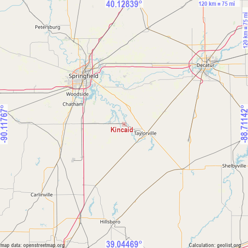
Kincaid GPS coordinates[2]
39° 35' 19.176" North, 89° 24' 52.344" West
| Map corner | latitude | longitude |
|---|---|---|
| Upper-left | 40.12839°, | -90.11767° |
| Center: | 39.58866°, | -89.41454° |
| Lower-right: | 39.04469°, | -88.71142° |
| Map W x H: | 120.5×120.5 km | = 74.9×74.9mi |
| max Lat: | 71.29058° ⇑50.2% North |
| Kincaid: | 39.58866° |
| min Lat: | ⇓49.8% South 19.06759° |
| min Long | Kincaid | max Long |
| -171.73463° | -89.41454° | -66.98998° |
| W 42.7%⇐ | ⇒57.3% E |
Elevation
Elevation of Kincaid is 185 m = 607 ft, and this is 109.8 m = 360 ft below average elevation for this country.
| Max E: |
3189 m = 10463 ft | 53.6% |
| Avg. | 294.8 m = 967 ft | |
| Kincaid | 185 m = 607 ft | |
Min E: |
-60 m = -197 ft | 46.4% |
See also: United States elevation on elevation.city.
Geographical zone
Kincaid is located in North temperate zone (between Tropic of Cancer and the Arctic Circle). Distance of this Northern Tropic circle is 1795.9 km =1115.9 mi to South.| Distance of | km | miles | from Kincaid |
|---|---|---|---|
| North Pole | 5605.2 | 3482.9 | to North |
| Arctic Circle | 2999.3 | 1863.7 | to North |
| Tropic Cancer | 1795.9 | 1115.9 | to South |
| Equator | 4401.8 | 2735.2 | to South |


Nearby cities:
15 places around Kincaid: (largest is in red/bold)
• Auburn
28.4 km =17.6 mi,  270°
270°
• Blue Mound
27.9 km =17.3 mi,  63°
63°
• Chatham
26.7 km =16.6 mi,  291°
291°
• Divernon
21 km =13 mi,  262°
262°
• Edinburg
7.9 km =4.9 mi,  15°
15°
• Farmersville
26 km =16.2 mi,  231°
231°
• Jerome
30.2 km =18.8 mi,  311°
311°
• Mechanicsburg
24.6 km =15.3 mi,  3°
3°
• Morrisonville
19.1 km =11.9 mi,  190°
190°
• Pawnee
14.2 km =8.8 mi, 271°
• Rochester
20.5 km =12.7 mi,  330°
330°
• Southern View
27.8 km =17.3 mi, 312°
• Stonington
19.8 km =12.3 mi,  73°
73°
• Taylorville
11.2 km =7 mi,  113°
113°
• Thayer
30.4 km =18.9 mi, 259°
Sources, notices
• [Note1] Compared only with cities in United States existing in our database
• [Src1] Map data: © OpenStreetMap contributors (CC-BY-SA)
• [Src2] Other city data from geonames.org with taken over terms of usage.
• [Src3] Geographical zone / Annual Mean Temperature by Robert A. Rohde @ Wikipedia
