Mechanicsburg geodata
Mechanicsburg (Illinois) is a populated place; located in United States in America/Chicago (GMT-5) time zone. With population of 629 people, there are 19367 cities with bigger population in this country. Compared to other cities in United States, 51.6% of cities are located further ↓South; 57.3% of cities are located further →East and 55.3% of cities have higher elevation than Mechanicsburg. Note1
Administrative division(s):
- Level 1: Illinois
- Level 2: Sangamon County
- Level 3: Township of Mechanicsburg


Mechanicsburg GPS coordinates[2]
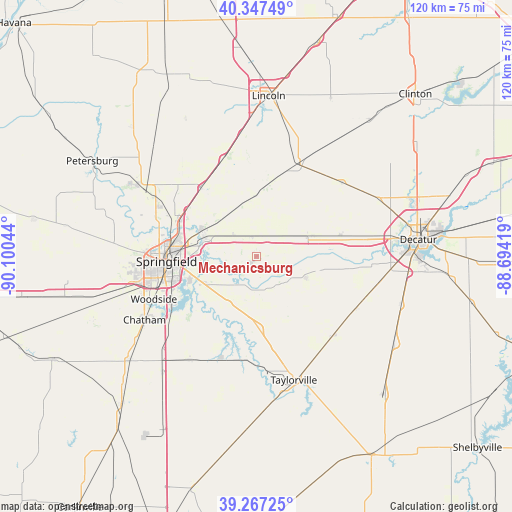
39° 48' 34.164" North, 89° 23' 50.316" West
| Map corner | latitude | longitude |
|---|---|---|
| Upper-left | 40.34749°, | -90.10044° |
| Center: | 39.80949°, | -89.39731° |
| Lower-right: | 39.26725°, | -88.69419° |
| Map W x H: | 120.1×120.1 km | = 74.6×74.6mi |
| max Lat: | 71.29058° ⇑48.4% North |
| Mechanicsburg: | 39.80949° |
| min Lat: | ⇓51.6% South 19.06759° |
| min Long | Mechanicsburg | max Long |
| -171.73463° | -89.39731° | -66.98998° |
| W 42.7%⇐ | ⇒57.3% E |
Elevation
Elevation of Mechanicsburg is 179 m = 587 ft, and this is 115.8 m = 380 ft below average elevation for this country.
| Max E: |
3189 m = 10463 ft | 55.3% |
| Avg. | 294.8 m = 967 ft | |
| Mechanicsburg | 179 m = 587 ft | |
Min E: |
-60 m = -197 ft | 44.7% |
See also: United States elevation on elevation.city.
Geographical zone
Mechanicsburg is located in North temperate zone (between Tropic of Cancer and the Arctic Circle). Distance of this Northern Tropic circle is 1820.5 km =1131.2 mi to South.| Distance of | km | miles | from Mechanicsburg |
|---|---|---|---|
| North Pole | 5580.7 | 3467.7 | to North |
| Arctic Circle | 2974.8 | 1848.5 | to North |
| Tropic Cancer | 1820.5 | 1131.2 | to South |
| Equator | 4426.4 | 2750.4 | to South |


Nearby cities:
15 places around Mechanicsburg: (largest is in red/bold)
• Edinburg
16.9 km =10.5 mi,  177°
177°
• Grandview
18.9 km =11.7 mi,  272°
272°
• Illiopolis
14.1 km =8.8 mi,  69°
69°
• Jerome
24.7 km =15.3 mi,  259°
259°
• Kincaid
24.6 km =15.3 mi, 183°
• Leland Grove
24.4 km =15.2 mi, 261°
• Mount Pulaski
24.4 km =15.2 mi,  23°
23°
• Niantic
20.3 km =12.6 mi,  75°
75°
• Riverton
12.7 km =7.9 mi,  287°
287°
• Rochester
13.3 km =8.3 mi,  239°
239°
• Sherman
20 km =12.4 mi,  297°
297°
• Southern View
22.7 km =14.1 mi, 255°
• Spaulding
13.7 km =8.5 mi, 297°
• Springfield
21.1 km =13.1 mi, 267°
• Williamsville
20.6 km =12.8 mi,  321°
321°
Sources, notices
• [Note1] Compared only with cities in United States existing in our database
• [Src1] Map data: © OpenStreetMap contributors (CC-BY-SA)
• [Src2] Other city data from geonames.org with taken over terms of usage.
• [Src3] Geographical zone / Annual Mean Temperature by Robert A. Rohde @ Wikipedia
