Litchfield geodata
Litchfield (Illinois) is a populated place; located in United States in America/Chicago (GMT-5) time zone. With population of 6,897 people, there are 5872 cities with bigger population in this country. Compared to other cities in United States, 53.3% of cities are located further ↑North; 58% of cities are located further →East and 52.8% of cities have lower elevation than Litchfield. Note1
Administrative division(s):
- Level 1: Illinois
- Level 2: Montgomery County
- Level 3: Township of North Litchfield


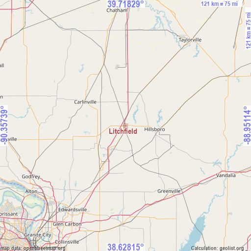
Litchfield GPS coordinates[2]
39° 10' 31.188" North, 89° 39' 15.336" West
| Map corner | latitude | longitude |
|---|---|---|
| Upper-left | 39.71829°, | -90.35739° |
| Center: | 39.17533°, | -89.65426° |
| Lower-right: | 38.62815°, | -88.95114° |
| Map W x H: | 121.2×121.2 km | = 75.3×75.3mi |
| max Lat: | 71.29058° ⇑53.3% North |
| Litchfield: | 39.17533° |
| min Lat: | ⇓46.7% South 19.06759° |
| min Long | Litchfield | max Long |
| -171.73463° | -89.65426° | -66.98998° |
| W 42%⇐ | ⇒58% E |
Elevation
Elevation of Litchfield is 209 m = 686 ft, and this is 85.8 m = 281 ft below average elevation for this country.
| Max E: |
3189 m = 10463 ft | 47.2% |
| Avg. | 294.8 m = 967 ft | |
| Litchfield | 209 m = 686 ft | |
Min E: |
-60 m = -197 ft | 52.8% |
See also: United States elevation on elevation.city.
Geographical zone
Litchfield is located in North temperate zone (between Tropic of Cancer and the Arctic Circle). Distance of this Northern Tropic circle is 1750 km =1087.4 mi to South.| Distance of | km | miles | from Litchfield |
|---|---|---|---|
| North Pole | 5651.2 | 3511.5 | to North |
| Arctic Circle | 3045.3 | 1892.3 | to North |
| Tropic Cancer | 1750 | 1087.4 | to South |
| Equator | 4355.9 | 2706.6 | to South |


Nearby cities:
15 places around Litchfield: (largest is in red/bold)
• Benld
15.8 km =9.8 mi,  234°
234°
• Bunker Hill
29.6 km =18.4 mi,  240°
240°
• Carlinville
22.8 km =14.2 mi,  300°
300°
• Coffeen
24.7 km =15.3 mi,  112°
112°
• Farmersville
29.8 km =18.5 mi,  0°
0°
• Gillespie
15.1 km =9.4 mi,  250°
250°
• Hillsboro
13.8 km =8.6 mi,  96°
96°
• Livingston
25 km =15.5 mi,  202°
202°
• Mount Olive
13.1 km =8.1 mi,  208°
208°
• Raymond
17.5 km =10.9 mi,  23°
23°
• Schram City
16.5 km =10.3 mi,  94°
94°
• Staunton
21.6 km =13.4 mi, 213°
• Taylor Springs
14.8 km =9.2 mi, 109°
• Wilsonville
20.9 km =13 mi, 236°
• Witt
27.9 km =17.3 mi,  71°
71°
Sources, notices
• [Note1] Compared only with cities in United States existing in our database
• [Src1] Map data: © OpenStreetMap contributors (CC-BY-SA)
• [Src2] Other city data from geonames.org with taken over terms of usage.
• [Src3] Geographical zone / Annual Mean Temperature by Robert A. Rohde @ Wikipedia
