Schram City geodata
Schram City (Illinois) is a populated place; located in United States in America/Chicago (GMT-5) time zone. With population of 570 people, there are 20030 cities with bigger population in this country. Compared to other cities in United States, 53.3% of cities are located further ↑North; 57.4% of cities are located further →East and 53.6% of cities have higher elevation than Schram City. Note1
Administrative division(s):
- Level 1: Illinois
- Level 2: Montgomery County
- Level 3: Township of East Fork


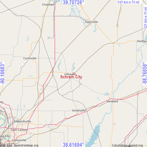
Schram City GPS coordinates[2]
39° 9' 51.156" North, 89° 27' 49.32" West
| Map corner | latitude | longitude |
|---|---|---|
| Upper-left | 39.70726°, | -90.16683° |
| Center: | 39.16421°, | -89.4637° |
| Lower-right: | 38.61694°, | -88.76058° |
| Map W x H: | 121.2×121.2 km | = 75.3×75.3mi |
| max Lat: | 71.29058° ⇑53.3% North |
| Schram City: | 39.16421° |
| min Lat: | ⇓46.7% South 19.06759° |
| min Long | Schram City | max Long |
| -171.73463° | -89.4637° | -66.98998° |
| W 42.6%⇐ | ⇒57.4% E |
Elevation
Elevation of Schram City is 185 m = 607 ft, and this is 109.8 m = 360 ft below average elevation for this country.
| Max E: |
3189 m = 10463 ft | 53.6% |
| Avg. | 294.8 m = 967 ft | |
| Schram City | 185 m = 607 ft | |
Min E: |
-60 m = -197 ft | 46.4% |
See also: United States elevation on elevation.city.
Geographical zone
Schram City is located in North temperate zone (between Tropic of Cancer and the Arctic Circle). Distance of this Northern Tropic circle is 1748.7 km =1086.6 mi to South.| Distance of | km | miles | from Schram City |
|---|---|---|---|
| North Pole | 5652.4 | 3512.2 | to North |
| Arctic Circle | 3046.5 | 1893 | to North |
| Tropic Cancer | 1748.7 | 1086.6 | to South |
| Equator | 4354.7 | 2705.9 | to South |


Nearby cities:
15 places around Schram City: (largest is in red/bold)
• Benld
30.4 km =18.9 mi,  254°
254°
• Coffeen
10.5 km =6.5 mi,  142°
142°
• Gillespie
30.9 km =19.2 mi,  262°
262°
• Greenville
30.6 km =19 mi,  171°
171°
• Hillsboro
2.8 km =1.7 mi, 263°
• Litchfield
16.5 km =10.3 mi,  274°
274°
• Morrisonville
28.5 km =17.7 mi,  1°
1°
• Mount Olive
24.9 km =15.5 mi, 245°
• Mulberry Grove
31.5 km =19.6 mi,  147°
147°
• Nokomis
21.6 km =13.4 mi,  45°
45°
• Ramsey
30.7 km =19.1 mi,  94°
94°
• Raymond
19.6 km =12.2 mi,  331°
331°
• Staunton
32.9 km =20.4 mi,  239°
239°
• Taylor Springs
4.4 km =2.7 mi,  213°
213°
• Witt
14.3 km =8.9 mi,  44°
44°
Sources, notices
• [Note1] Compared only with cities in United States existing in our database
• [Src1] Map data: © OpenStreetMap contributors (CC-BY-SA)
• [Src2] Other city data from geonames.org with taken over terms of usage.
• [Src3] Geographical zone / Annual Mean Temperature by Robert A. Rohde @ Wikipedia
