Metropolis geodata
Metropolis (Illinois) is a seat of a second-order administrative division; located in United States in America/Chicago (GMT-5) time zone. With population of 6,334 people, there are 6198 cities with bigger population in this country. Compared to other cities in United States, 65.5% of cities are located further ↑North; 55.4% of cities are located further →East and 68.3% of cities have higher elevation than Metropolis. Note1


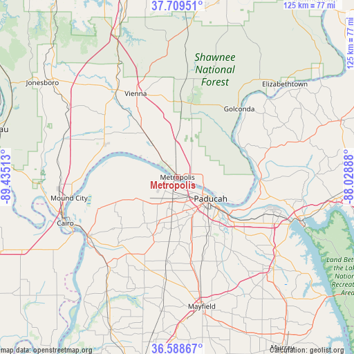
Metropolis GPS coordinates[2]
37° 9' 4.212" North, 88° 43' 55.2" West
| Map corner | latitude | longitude |
|---|---|---|
| Upper-left | 37.70951°, | -89.43513° |
| Center: | 37.15117°, | -88.732° |
| Lower-right: | 36.58867°, | -88.02888° |
| Map W x H: | 124.6×124.6 km | = 77.4×77.4mi |
| max Lat: | 71.29058° ⇑65.5% North |
| Metropolis: | 37.15117° |
| min Lat: | ⇓34.5% South 19.06759° |
| min Long | Metropolis | max Long |
| -171.73463° | -88.732° | -66.98998° |
| W 44.6%⇐ | ⇒55.4% E |
Elevation
Elevation of Metropolis is 111 m = 364 ft, and this is 183.8 m = 603 ft below average elevation for this country.
| Max E: |
3189 m = 10463 ft | 68.3% |
| Avg. | 294.8 m = 967 ft | |
| Metropolis | 111 m = 364 ft | |
Min E: |
-60 m = -197 ft | 31.7% |
See also: United States elevation on elevation.city.
Geographical zone
Metropolis is located in North temperate zone (between Tropic of Cancer and the Arctic Circle). Distance of this Northern Tropic circle is 1524.9 km =947.5 mi to South.| Distance of | km | miles | from Metropolis |
|---|---|---|---|
| North Pole | 5876.2 | 3651.3 | to North |
| Arctic Circle | 3270.4 | 2032.1 | to North |
| Tropic Cancer | 1524.9 | 947.5 | to South |
| Equator | 4130.8 | 2566.8 | to South |


Nearby cities:
15 places around Metropolis: (largest is in red/bold)
• Barlow
30 km =18.6 mi,  248°
248°
• Brookport
9.5 km =5.9 mi,  108°
108°
• Calvert City
36.3 km =22.6 mi, 111°
• Farley
18.6 km =11.6 mi,  128°
128°
• Golconda
32.4 km =20.1 mi,  42°
42°
• Hendron
15.4 km =9.6 mi,  143°
143°
• Kevil
15.6 km =9.7 mi,  241°
241°
• La Center
23 km =14.3 mi, 248°
• Ledbetter
25.4 km =15.8 mi,  116°
116°
• Massac
14.9 km =9.3 mi,  179°
179°
• Paducah
13.9 km =8.6 mi, 122°
• Reidland
23.2 km =14.4 mi, 129°
• Smithland
29.2 km =18.1 mi,  92°
92°
• Symsonia
31.8 km =19.8 mi, 143°
• Vienna
32.8 km =20.4 mi,  333°
333°
Sources, notices
• [Note1] Compared only with cities in United States existing in our database
• [Src1] Map data: © OpenStreetMap contributors (CC-BY-SA)
• [Src2] Other city data from geonames.org with taken over terms of usage.
• [Src3] Geographical zone / Annual Mean Temperature by Robert A. Rohde @ Wikipedia
