Farley geodata
Farley (Kentucky) is a populated place; located in United States in America/Chicago (GMT-5) time zone. With population of 4,701 people, there are 7443 cities with bigger population in this country. Compared to other cities in United States, 66% of cities are located further ↑North; 54.9% of cities are located further →East and 69.2% of cities have higher elevation than Farley. Note1


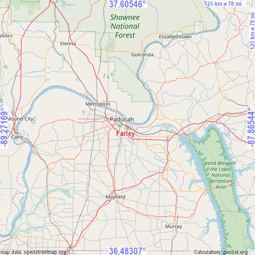
Farley GPS coordinates[2]
37° 2' 46.824" North, 88° 34' 6.816" West
| Map corner | latitude | longitude |
|---|---|---|
| Upper-left | 37.60546°, | -89.27169° |
| Center: | 37.04634°, | -88.56856° |
| Lower-right: | 36.48307°, | -87.86544° |
| Map W x H: | 124.8×124.8 km | = 77.5×77.5mi |
| max Lat: | 71.29058° ⇑66% North |
| Farley: | 37.04634° |
| min Lat: | ⇓34% South 19.06759° |
| min Long | Farley | max Long |
| -171.73463° | -88.56856° | -66.98998° |
| W 45.1%⇐ | ⇒54.9% E |
Elevation
Elevation of Farley is 105 m = 344 ft, and this is 189.8 m = 623 ft below average elevation for this country.
| Max E: |
3189 m = 10463 ft | 69.2% |
| Avg. | 294.8 m = 967 ft | |
| Farley | 105 m = 344 ft | |
Min E: |
-60 m = -197 ft | 30.8% |
See also: United States elevation on elevation.city.
Geographical zone
Farley is located in North temperate zone (between Tropic of Cancer and the Arctic Circle). Distance of this Northern Tropic circle is 1513.2 km =940.3 mi to South.| Distance of | km | miles | from Farley |
|---|---|---|---|
| North Pole | 5887.9 | 3658.6 | to North |
| Arctic Circle | 3282 | 2039.3 | to North |
| Tropic Cancer | 1513.2 | 940.3 | to South |
| Equator | 4119.2 | 2559.6 | to South |


Nearby cities:
15 places around Farley: (largest is in red/bold)
• Benton
28.6 km =17.8 mi,  137°
137°
• Brookport
10.2 km =6.3 mi,  327°
327°
• Calvert City
19.4 km =12.1 mi,  94°
94°
• Golconda
36.4 km =22.6 mi,  11°
11°
• Hendron
5.4 km =3.4 mi,  261°
261°
• Kevil
28.6 km =17.8 mi,  278°
278°
• La Center
36.1 km =22.4 mi, 275°
• Ledbetter
8.1 km =5 mi, 89°
• Massac
14.8 km =9.2 mi, 257°
• Mayfield
34.4 km =21.4 mi,  190°
190°
• Metropolis
18.6 km =11.6 mi,  308°
308°
• Paducah
5 km =3.1 mi, 325°
• Reidland
4.6 km =2.9 mi,  134°
134°
• Smithland
17.9 km =11.1 mi,  54°
54°
• Symsonia
14.7 km =9.1 mi,  162°
162°
Sources, notices
• [Note1] Compared only with cities in United States existing in our database
• [Src1] Map data: © OpenStreetMap contributors (CC-BY-SA)
• [Src2] Other city data from geonames.org with taken over terms of usage.
• [Src3] Geographical zone / Annual Mean Temperature by Robert A. Rohde @ Wikipedia
