Murphysboro geodata
Murphysboro (Illinois) is a seat of a second-order administrative division; located in United States in America/Chicago (GMT-5) time zone. With population of 7,768 people, there are 5397 cities with bigger population in this country. Compared to other cities in United States, 62.9% of cities are located further ↑North; 57.1% of cities are located further →East and 65.5% of cities have higher elevation than Murphysboro. Note1
Administrative division(s):
- Level 1: Illinois
- Level 2: Jackson County
- Level 3: Township of Murphysboro


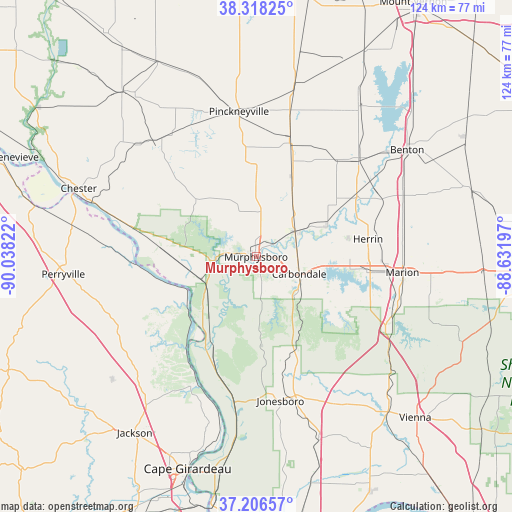
Murphysboro GPS coordinates[2]
37° 45' 52.2" North, 89° 20' 6.324" West
| Map corner | latitude | longitude |
|---|---|---|
| Upper-left | 38.31825°, | -90.03822° |
| Center: | 37.7645°, | -89.33509° |
| Lower-right: | 37.20657°, | -88.63197° |
| Map W x H: | 123.6×123.6 km | = 76.8×76.8mi |
| max Lat: | 71.29058° ⇑62.9% North |
| Murphysboro: | 37.7645° |
| min Lat: | ⇓37.1% South 19.06759° |
| min Long | Murphysboro | max Long |
| -171.73463° | -89.33509° | -66.98998° |
| W 42.9%⇐ | ⇒57.1% E |
Elevation
Elevation of Murphysboro is 126 m = 413 ft, and this is 168.8 m = 554 ft below average elevation for this country.
| Max E: |
3189 m = 10463 ft | 65.5% |
| Avg. | 294.8 m = 967 ft | |
| Murphysboro | 126 m = 413 ft | |
Min E: |
-60 m = -197 ft | 34.5% |
See also: United States elevation on elevation.city.
Geographical zone
Murphysboro is located in North temperate zone (between Tropic of Cancer and the Arctic Circle). Distance of this Northern Tropic circle is 1593.1 km =989.9 mi to South.| Distance of | km | miles | from Murphysboro |
|---|---|---|---|
| North Pole | 5808 | 3608.9 | to North |
| Arctic Circle | 3202.2 | 1989.8 | to North |
| Tropic Cancer | 1593.1 | 989.9 | to South |
| Equator | 4199 | 2609.1 | to South |


Nearby cities:
15 places around Murphysboro: (largest is in red/bold)
• Ava
19.7 km =12.2 mi,  314°
314°
• Cambria
19.1 km =11.9 mi,  84°
84°
• Carbondale
11.2 km =7 mi,  111°
111°
• Carterville
22.7 km =14.1 mi,  91°
91°
• Cobden
26.9 km =16.7 mi,  164°
164°
• Crainville
23.5 km =14.6 mi, 93°
• De Soto
11.1 km =6.9 mi,  57°
57°
• Elkville
18.4 km =11.4 mi,  28°
28°
• Energy
27.1 km =16.8 mi, 87°
• Grand Tower
21 km =13 mi,  223°
223°
• Harrison
3.6 km =2.2 mi,  357°
357°
• Herrin
27.4 km =17 mi, 80°
• Hurst
18.5 km =11.5 mi,  65°
65°
• Makanda
19.8 km =12.3 mi,  145°
145°
• Royalton
23.1 km =14.4 mi, 57°
Sources, notices
• [Note1] Compared only with cities in United States existing in our database
• [Src1] Map data: © OpenStreetMap contributors (CC-BY-SA)
• [Src2] Other city data from geonames.org with taken over terms of usage.
• [Src3] Geographical zone / Annual Mean Temperature by Robert A. Rohde @ Wikipedia
