Grand Tower geodata
Grand Tower (Illinois) is a populated place; located in United States in America/Chicago (GMT-5) time zone. With population of 588 people, there are 19837 cities with bigger population in this country. Compared to other cities in United States, 63.5% of cities are located further ↑North; 57.5% of cities are located further →East and 68.5% of cities have higher elevation than Grand Tower. Note1
Administrative division(s):
- Level 1: Illinois
- Level 2: Jackson County
- Level 3: Township of Grand Tower


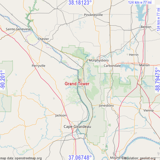
Grand Tower GPS coordinates[2]
37° 37' 35.184" North, 89° 29' 52.332" West
| Map corner | latitude | longitude |
|---|---|---|
| Upper-left | 38.18123°, | -90.201° |
| Center: | 37.62644°, | -89.49787° |
| Lower-right: | 37.06748°, | -88.79475° |
| Map W x H: | 123.8×123.8 km | = 76.9×76.9mi |
| max Lat: | 71.29058° ⇑63.5% North |
| Grand Tower: | 37.62644° |
| min Lat: | ⇓36.5% South 19.06759° |
| min Long | Grand Tower | max Long |
| -171.73463° | -89.49787° | -66.98998° |
| W 42.5%⇐ | ⇒57.5% E |
Elevation
Elevation of Grand Tower is 110 m = 361 ft, and this is 184.8 m = 606 ft below average elevation for this country.
| Max E: |
3189 m = 10463 ft | 68.5% |
| Avg. | 294.8 m = 967 ft | |
| Grand Tower | 110 m = 361 ft | |
Min E: |
-60 m = -197 ft | 31.5% |
See also: United States elevation on elevation.city.
Geographical zone
Grand Tower is located in North temperate zone (between Tropic of Cancer and the Arctic Circle). Distance of this Northern Tropic circle is 1577.7 km =980.3 mi to South.| Distance of | km | miles | from Grand Tower |
|---|---|---|---|
| North Pole | 5823.4 | 3618.5 | to North |
| Arctic Circle | 3217.5 | 1999.3 | to North |
| Tropic Cancer | 1577.7 | 980.3 | to South |
| Equator | 4183.7 | 2599.6 | to South |


Nearby cities:
15 places around Grand Tower: (largest is in red/bold)
• Anna
28.8 km =17.9 mi,  129°
129°
• Ava
29.1 km =18.1 mi,  0°
0°
• Cambria
37.5 km =23.3 mi,  62°
62°
• Cape Girardeau
35.7 km =22.2 mi,  182°
182°
• Carbondale
27.2 km =16.9 mi,  65°
65°
• Cobden
24 km =14.9 mi,  116°
116°
• De Soto
31.9 km =19.8 mi,  48°
48°
• Elkville
39 km =24.2 mi,  36°
36°
• Harrison
23.6 km =14.7 mi, 36°
• Hurst
38.8 km =24.1 mi, 53°
• Jackson
30.9 km =19.2 mi,  208°
208°
• Jonesboro
28.1 km =17.5 mi, 133°
• Makanda
25.5 km =15.8 mi,  92°
92°
• Murphysboro
21 km =13 mi, 43°
• Perryville
33.8 km =21 mi,  288°
288°
Sources, notices
• [Note1] Compared only with cities in United States existing in our database
• [Src1] Map data: © OpenStreetMap contributors (CC-BY-SA)
• [Src2] Other city data from geonames.org with taken over terms of usage.
• [Src3] Geographical zone / Annual Mean Temperature by Robert A. Rohde @ Wikipedia
