Cobden geodata
Cobden (Illinois) is a populated place; located in United States in America/Chicago (GMT-5) time zone. With population of 1,139 people, there are 15444 cities with bigger population in this country. Compared to other cities in United States, 63.9% of cities are located further ↑North; 56.9% of cities are located further →East and 55.7% of cities have higher elevation than Cobden. Note1


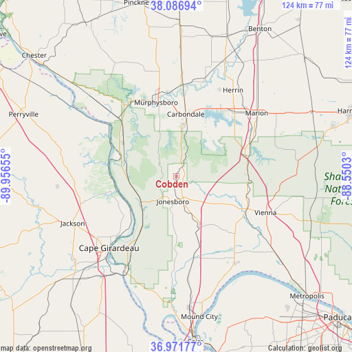
Cobden GPS coordinates[2]
37° 31' 53.184" North, 89° 15' 12.312" West
| Map corner | latitude | longitude |
|---|---|---|
| Upper-left | 38.08694°, | -89.95655° |
| Center: | 37.53144°, | -89.25342° |
| Lower-right: | 36.97177°, | -88.5503° |
| Map W x H: | 124×124 km | = 77.1×77.1mi |
| max Lat: | 71.29058° ⇑63.9% North |
| Cobden: | 37.53144° |
| min Lat: | ⇓36.1% South 19.06759° |
| min Long | Cobden | max Long |
| -171.73463° | -89.25342° | -66.98998° |
| W 43.1%⇐ | ⇒56.9% E |
Elevation
Elevation of Cobden is 177 m = 581 ft, and this is 117.8 m = 386 ft below average elevation for this country.
| Max E: |
3189 m = 10463 ft | 55.7% |
| Avg. | 294.8 m = 967 ft | |
| Cobden | 177 m = 581 ft | |
Min E: |
-60 m = -197 ft | 44.3% |
See also: United States elevation on elevation.city.
Geographical zone
Cobden is located in North temperate zone (between Tropic of Cancer and the Arctic Circle). Distance of this Northern Tropic circle is 1567.2 km =973.8 mi to South.| Distance of | km | miles | from Cobden |
|---|---|---|---|
| North Pole | 5834 | 3625.1 | to North |
| Arctic Circle | 3228.1 | 2005.8 | to North |
| Tropic Cancer | 1567.2 | 973.8 | to South |
| Equator | 4173.1 | 2593 | to South |


Nearby cities:
15 places around Cobden: (largest is in red/bold)
• Anna
7.9 km =4.9 mi,  175°
175°
• Cambria
30.2 km =18.8 mi,  23°
23°
• Carbondale
22 km =13.7 mi,  8°
8°
• Carterville
29.8 km =18.5 mi,  31°
31°
• Crainville
29.5 km =18.3 mi, 33°
• De Soto
31.9 km =19.8 mi,  4°
4°
• Dongola
20.4 km =12.7 mi,  157°
157°
• Energy
33.6 km =20.9 mi,  36°
36°
• Goreville
24.9 km =15.5 mi,  84°
84°
• Grand Tower
24 km =14.9 mi,  296°
296°
• Harrison
30.4 km =18.9 mi,  345°
345°
• Jonesboro
9 km =5.6 mi,  188°
188°
• Makanda
10.3 km =6.4 mi, 22°
• Murphysboro
26.9 km =16.7 mi,  344°
344°
• Tamms
33 km =20.5 mi, 182°
Sources, notices
• [Note1] Compared only with cities in United States existing in our database
• [Src1] Map data: © OpenStreetMap contributors (CC-BY-SA)
• [Src2] Other city data from geonames.org with taken over terms of usage.
• [Src3] Geographical zone / Annual Mean Temperature by Robert A. Rohde @ Wikipedia
