Lawrenceville geodata
Lawrenceville (Illinois) is a seat of a second-order administrative division; located in United States in America/Chicago (GMT-5) time zone. With population of 4,427 people, there are 7716 cities with bigger population in this country. Compared to other cities in United States, 57.2% of cities are located further ↑North; 51.4% of cities are located further →East and 62.2% of cities have higher elevation than Lawrenceville. Note1
Administrative division(s):
- Level 1: Illinois
- Level 2: Lawrence County
- Level 3: Township of Lawrence


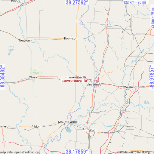
Lawrenceville GPS coordinates[2]
38° 43' 45.156" North, 87° 40' 54.084" West
| Map corner | latitude | longitude |
|---|---|---|
| Upper-left | 39.27562°, | -88.38482° |
| Center: | 38.72921°, | -87.68169° |
| Lower-right: | 38.17859°, | -86.97857° |
| Map W x H: | 122×122 km | = 75.8×75.8mi |
| max Lat: | 71.29058° ⇑57.2% North |
| Lawrenceville: | 38.72921° |
| min Lat: | ⇓42.8% South 19.06759° |
| min Long | Lawrenceville | max Long |
| -171.73463° | -87.68169° | -66.98998° |
| W 48.6%⇐ | ⇒51.4% E |
Elevation
Elevation of Lawrenceville is 143 m = 469 ft, and this is 151.8 m = 498 ft below average elevation for this country.
| Max E: |
3189 m = 10463 ft | 62.2% |
| Avg. | 294.8 m = 967 ft | |
| Lawrenceville | 143 m = 469 ft | |
Min E: |
-60 m = -197 ft | 37.8% |
See also: United States elevation on elevation.city.
Geographical zone
Lawrenceville is located in North temperate zone (between Tropic of Cancer and the Arctic Circle). Distance of this Northern Tropic circle is 1700.4 km =1056.6 mi to South.| Distance of | km | miles | from Lawrenceville |
|---|---|---|---|
| North Pole | 5700.8 | 3542.3 | to North |
| Arctic Circle | 3094.9 | 1923.1 | to North |
| Tropic Cancer | 1700.4 | 1056.6 | to South |
| Equator | 4306.3 | 2675.8 | to South |


Nearby cities:
15 places around Lawrenceville: (largest is in red/bold)
• Bicknell
32.8 km =20.4 mi,  81°
81°
• Bridgeport
7.3 km =4.5 mi,  249°
249°
• Carlisle
35.8 km =22.2 mi,  41°
41°
• Freelandville
35.9 km =22.3 mi,  65°
65°
• Monroe City
31.1 km =19.3 mi,  114°
114°
• Mount Carmel
36.1 km =22.4 mi,  191°
191°
• Oaktown
26.1 km =16.2 mi,  52°
52°
• Oblong
36.2 km =22.5 mi,  327°
327°
• Olney
35 km =21.7 mi,  270°
270°
• Palestine
31.1 km =19.3 mi,  11°
11°
• Robinson
31.1 km =19.3 mi,  350°
350°
• Saint Francisville
15.6 km =9.7 mi,  168°
168°
• Sumner
15.7 km =9.8 mi, 265°
• Vincennes
14.5 km =9 mi, 113°
• West Salem
36.4 km =22.6 mi,  230°
230°
Sources, notices
• [Note1] Compared only with cities in United States existing in our database
• [Src1] Map data: © OpenStreetMap contributors (CC-BY-SA)
• [Src2] Other city data from geonames.org with taken over terms of usage.
• [Src3] Geographical zone / Annual Mean Temperature by Robert A. Rohde @ Wikipedia
