Mount Vernon geodata
Mount Vernon (Illinois) is a seat of a second-order administrative division; located in United States in America/Chicago (GMT-5) time zone. With population of 15,087 people, there are 3232 cities with bigger population in this country. Compared to other cities in United States, 59.8% of cities are located further ↑North; 55.9% of cities are located further →East and 59.9% of cities have higher elevation than Mount Vernon. Note1
Administrative division(s):
- Level 1: Illinois
- Level 2: Jefferson County
- Level 3: Township of Mount Vernon


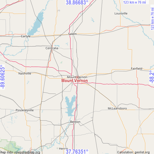
Mount Vernon GPS coordinates[2]
38° 19' 2.172" North, 88° 54' 11.232" West
| Map corner | latitude | longitude |
|---|---|---|
| Upper-left | 38.86683°, | -89.60625° |
| Center: | 38.31727°, | -88.90312° |
| Lower-right: | 37.76351°, | -88.2° |
| Map W x H: | 122.7×122.7 km | = 76.2×76.2mi |
| max Lat: | 71.29058° ⇑59.8% North |
| Mount Vernon: | 38.31727° |
| min Lat: | ⇓40.2% South 19.06759° |
| min Long | Mount Vernon | max Long |
| -171.73463° | -88.90312° | -66.98998° |
| W 44.1%⇐ | ⇒55.9% E |
Elevation
Elevation of Mount Vernon is 155 m = 509 ft, and this is 139.8 m = 459 ft below average elevation for this country.
| Max E: |
3189 m = 10463 ft | 59.9% |
| Avg. | 294.8 m = 967 ft | |
| Mount Vernon | 155 m = 509 ft | |
Min E: |
-60 m = -197 ft | 40.1% |
See also: United States elevation on elevation.city.
Geographical zone
Mount Vernon is located in North temperate zone (between Tropic of Cancer and the Arctic Circle). Distance of this Northern Tropic circle is 1654.6 km =1028.1 mi to South.| Distance of | km | miles | from Mount Vernon |
|---|---|---|---|
| North Pole | 5746.6 | 3570.8 | to North |
| Arctic Circle | 3140.7 | 1951.5 | to North |
| Tropic Cancer | 1654.6 | 1028.1 | to South |
| Equator | 4260.5 | 2647.4 | to South |


Nearby cities:
15 places around Mount Vernon: (largest is in red/bold)
• Ashley
25.1 km =15.6 mi,  273°
273°
• Benton
35.7 km =22.2 mi,  182°
182°
• Bluford
15.5 km =9.6 mi,  84°
84°
• Central City
32.3 km =20.1 mi,  322°
322°
• Centralia
30.6 km =19 mi, 319°
• Dahlgren
23.2 km =14.4 mi,  124°
124°
• Hoyleton
35.2 km =21.9 mi,  293°
293°
• Ina
18.5 km =11.5 mi, 180°
• Irvington
26.4 km =16.4 mi,  300°
300°
• Salem
34.6 km =21.5 mi,  353°
353°
• Sesser
28.2 km =17.5 mi,  207°
207°
• Tamaroa
34.8 km =21.6 mi,  235°
235°
• Wamac
29.7 km =18.5 mi, 315°
• Wayne City
27.7 km =17.2 mi, 83°
• Woodlawn
11.4 km =7.1 mi,  277°
277°
Sources, notices
• [Note1] Compared only with cities in United States existing in our database
• [Src1] Map data: © OpenStreetMap contributors (CC-BY-SA)
• [Src2] Other city data from geonames.org with taken over terms of usage.
• [Src3] Geographical zone / Annual Mean Temperature by Robert A. Rohde @ Wikipedia
