Springfield geodata
Springfield (Illinois) is a seat of a first-order administrative division; located in United States in America/Chicago (GMT-5) time zone. With population of 116,565 people, there are 272 cities with bigger population in this country. Compared to other cities in United States, 51.5% of cities are located further ↓South; 58% of cities are located further →East and 53.9% of cities have higher elevation than Springfield. Note1


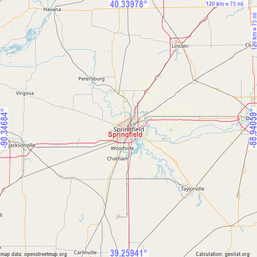
Springfield GPS coordinates[2]
39° 48' 6.192" North, 89° 38' 37.356" West
| Map corner | latitude | longitude |
|---|---|---|
| Upper-left | 40.33978°, | -90.34684° |
| Center: | 39.80172°, | -89.64371° |
| Lower-right: | 39.25941°, | -88.94059° |
| Map W x H: | 120.1×120.1 km | = 74.6×74.6mi |
| max Lat: | 71.29058° ⇑48.5% North |
| Springfield: | 39.80172° |
| min Lat: | ⇓51.5% South 19.06759° |
| min Long | Springfield | max Long |
| -171.73463° | -89.64371° | -66.98998° |
| W 42%⇐ | ⇒58% E |
Elevation
Elevation of Springfield is 184 m = 604 ft, and this is 110.8 m = 364 ft below average elevation for this country.
| Max E: |
3189 m = 10463 ft | 53.9% |
| Avg. | 294.8 m = 967 ft | |
| Springfield | 184 m = 604 ft | |
Min E: |
-60 m = -197 ft | 46.1% |
See also: Springfield elevation on elevation.city.
Geographical zone
Springfield is located in North temperate zone (between Tropic of Cancer and the Arctic Circle). Distance of this Northern Tropic circle is 1819.6 km =1130.6 mi to South.| Distance of | km | miles | from Springfield |
|---|---|---|---|
| North Pole | 5581.5 | 3468.2 | to North |
| Arctic Circle | 2975.6 | 1849 | to North |
| Tropic Cancer | 1819.6 | 1130.6 | to South |
| Equator | 4425.5 | 2749.9 | to South |


Nearby cities:
15 places around Springfield: (largest is in red/bold)
• Athens
19 km =11.8 mi,  338°
338°
• Chatham
14.9 km =9.3 mi,  200°
200°
• Grandview
2.7 km =1.7 mi,  52°
52°
• Jerome
4.9 km =3 mi,  219°
219°
• Leland Grove
4.1 km =2.5 mi,  227°
227°
• Loami
22.3 km =13.9 mi, 231°
• Mechanicsburg
21.1 km =13.1 mi,  87°
87°
• New Berlin
24.3 km =15.1 mi,  249°
249°
• Pawnee
24 km =14.9 mi,  166°
166°
• Riverton
10.1 km =6.3 mi,  62°
62°
• Rochester
11.2 km =7 mi,  121°
121°
• Sherman
10.7 km =6.6 mi,  17°
17°
• Southern View
5 km =3.1 mi,  189°
189°
• Spaulding
11.4 km =7.1 mi, 50°
• Williamsville
18.8 km =11.7 mi,  25°
25°
Sources, notices
• [Note1] Compared only with cities in United States existing in our database
• [Src1] Map data: © OpenStreetMap contributors (CC-BY-SA)
• [Src2] Other city data from geonames.org with taken over terms of usage.
• [Src3] Geographical zone / Annual Mean Temperature by Robert A. Rohde @ Wikipedia
