Carmel geodata
Carmel (Indiana) is a populated place; located in United States in America/Indiana/Indianapolis (GMT-4) time zone. With population of 88,713 people, there are 415 cities with bigger population in this country. Compared to other cities in United States, 53.4% of cities are located further ↓South; 52.6% of cities are located further ←West and 65% of cities have lower elevation than Carmel. Note1


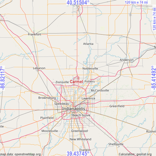
Carmel GPS coordinates[2]
39° 58' 42.132" North, 86° 7' 4.944" West
| Map corner | latitude | longitude |
|---|---|---|
| Upper-left | 40.51504°, | -86.82117° |
| Center: | 39.97837°, | -86.11804° |
| Lower-right: | 39.43745°, | -85.41492° |
| Map W x H: | 119.8×119.8 km | = 74.4×74.4mi |
| max Lat: | 71.29058° ⇑46.6% North |
| Carmel: | 39.97837° |
| min Lat: | ⇓53.4% South 19.06759° |
| min Long | Carmel | max Long |
| -171.73463° | -86.11804° | -66.98998° |
| W 52.6%⇐ | ⇒47.4% E |
Elevation
Elevation of Carmel is 262 m = 860 ft, and this is 32.8 m = 108 ft below average elevation for this country.
| Max E: |
3189 m = 10463 ft | 35% |
| Avg. | 294.8 m = 967 ft | |
| Carmel | 262 m = 860 ft | |
Min E: |
-60 m = -197 ft | 65% |
See also: Carmel elevation on elevation.city.
Geographical zone
Carmel is located in North temperate zone (between Tropic of Cancer and the Arctic Circle). Distance of this Northern Tropic circle is 1839.3 km =1142.9 mi to South.| Distance of | km | miles | from Carmel |
|---|---|---|---|
| North Pole | 5561.9 | 3456 | to North |
| Arctic Circle | 2956 | 1836.8 | to North |
| Tropic Cancer | 1839.3 | 1142.9 | to South |
| Equator | 4445.2 | 2762.1 | to South |


Nearby cities:
15 places around Carmel: (largest is in red/bold)
• Arcadia
23.4 km =14.5 mi,  20°
20°
• Broad Ripple
12.6 km =7.8 mi,  189°
189°
• Cicero
18.5 km =11.5 mi,  28°
28°
• Fishers
9.2 km =5.7 mi,  105°
105°
• Lawrence
17.4 km =10.8 mi,  153°
153°
• McCordsville
18.4 km =11.4 mi,  115°
115°
• Meridian Hills
10.4 km =6.5 mi,  198°
198°
• Noblesville
11.9 km =7.4 mi,  51°
51°
• Rocky Ripple
15.2 km =9.4 mi, 197°
• Sheridan
19.5 km =12.1 mi,  333°
333°
• Speedway
23.4 km =14.5 mi,  213°
213°
• Warren Park
22.6 km =14 mi,  165°
165°
• Westfield
7.2 km =4.5 mi,  353°
353°
• Whitestown
19.5 km =12.1 mi,  276°
276°
• Zionsville
12.6 km =7.8 mi,  255°
255°
Sources, notices
• [Note1] Compared only with cities in United States existing in our database
• [Src1] Map data: © OpenStreetMap contributors (CC-BY-SA)
• [Src2] Other city data from geonames.org with taken over terms of usage.
• [Src3] Geographical zone / Annual Mean Temperature by Robert A. Rohde @ Wikipedia
