Noblesville geodata
Noblesville (Indiana) is a seat of a second-order administrative division; located in United States in America/Indiana/Indianapolis (GMT-4) time zone. With population of 59,093 people, there are 763 cities with bigger population in this country. Compared to other cities in United States, 54% of cities are located further ↓South; 52.9% of cities are located further ←West and 59.1% of cities have lower elevation than Noblesville. Note1
Administrative division(s):
- Level 1: Indiana
- Level 2: Hamilton County
- Level 3: Township of Noblesville


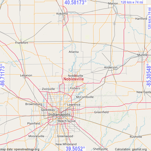
Noblesville GPS coordinates[2]
40° 2' 44.124" North, 86° 0' 30.96" West
| Map corner | latitude | longitude |
|---|---|---|
| Upper-left | 40.58173°, | -86.71173° |
| Center: | 40.04559°, | -86.0086° |
| Lower-right: | 39.5052°, | -85.30548° |
| Map W x H: | 119.7×119.7 km | = 74.4×74.4mi |
| max Lat: | 71.29058° ⇑46% North |
| Noblesville: | 40.04559° |
| min Lat: | ⇓54% South 19.06759° |
| min Long | Noblesville | max Long |
| -171.73463° | -86.0086° | -66.98998° |
| W 52.9%⇐ | ⇒47.1% E |
Elevation
Elevation of Noblesville is 236 m = 774 ft, and this is 58.8 m = 193 ft below average elevation for this country.
| Max E: |
3189 m = 10463 ft | 40.9% |
| Avg. | 294.8 m = 967 ft | |
| Noblesville | 236 m = 774 ft | |
Min E: |
-60 m = -197 ft | 59.1% |
See also: Noblesville elevation on elevation.city.
Geographical zone
Noblesville is located in North temperate zone (between Tropic of Cancer and the Arctic Circle). Distance of this Northern Tropic circle is 1846.7 km =1147.5 mi to South.| Distance of | km | miles | from Noblesville |
|---|---|---|---|
| North Pole | 5554.4 | 3451.3 | to North |
| Arctic Circle | 2948.5 | 1832.1 | to North |
| Tropic Cancer | 1846.7 | 1147.5 | to South |
| Equator | 4452.7 | 2766.8 | to South |


Nearby cities:
15 places around Noblesville: (largest is in red/bold)
• Arcadia
14.5 km =9 mi,  355°
355°
• Atlanta
18.9 km =11.7 mi, 355°
• Broad Ripple
22.9 km =14.2 mi,  209°
209°
• Carmel
11.9 km =7.4 mi,  231°
231°
• Cicero
8.7 km =5.4 mi, 357°
• Fishers
10 km =6.2 mi,  182°
182°
• Fortville
18.6 km =11.6 mi,  132°
132°
• Ingalls
19.9 km =12.4 mi,  119°
119°
• Lapel
13.9 km =8.6 mi,  79°
79°
• Lawrence
23.1 km =14.4 mi, 183°
• McCordsville
16.9 km =10.5 mi,  154°
154°
• Meridian Hills
21.4 km =13.3 mi,  216°
216°
• Pendleton
22.9 km =14.2 mi,  103°
103°
• Sheridan
20.6 km =12.8 mi,  298°
298°
• Westfield
10.1 km =6.3 mi,  268°
268°
Sources, notices
• [Note1] Compared only with cities in United States existing in our database
• [Src1] Map data: © OpenStreetMap contributors (CC-BY-SA)
• [Src2] Other city data from geonames.org with taken over terms of usage.
• [Src3] Geographical zone / Annual Mean Temperature by Robert A. Rohde @ Wikipedia
