Saint Mary-of-the-Woods geodata
Saint Mary-of-the-Woods (Indiana) is a populated place; located in United States in America/Indiana/Indianapolis (GMT-4) time zone. With population of 797 people, there are 17838 cities with bigger population in this country. Compared to other cities in United States, 50.8% of cities are located further ↑North; 50.7% of cities are located further →East and 56.9% of cities have higher elevation than Saint Mary-of-the-Woods. Note1
Current local time in Saint Mary-of-the-Woods:
02:50 AM, WednesdayDifference from your time zone: hours


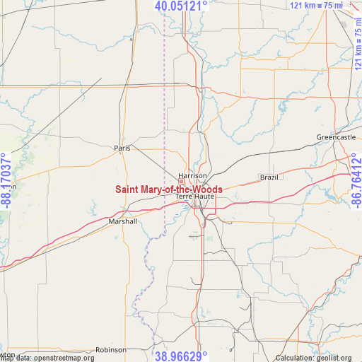
Saint Mary-of-the-Woods GPS coordinates[2]
39° 30' 39.132" North, 87° 28' 2.064" West
| Map corner | latitude | longitude |
|---|---|---|
| Upper-left | 40.05121°, | -88.17037° |
| Center: | 39.51087°, | -87.46724° |
| Lower-right: | 38.96629°, | -86.76412° |
| Map W x H: | 120.6×120.6 km | = 74.9×74.9mi |
| max Lat: | 71.29058° ⇑50.8% North |
| Saint Mary-of-the-Woods: | 39.51087° |
| min Lat: | ⇓49.2% South 19.06759° |
| min Long | Saint Mary-of-t | max Long |
| -171.73463° | -87.46724° | -66.98998° |
| W 49.3%⇐ | ⇒50.7% E |
Elevation
Elevation of Saint Mary-of-the-Woods is 171 m = 561 ft, and this is 123.8 m = 406 ft below average elevation for this country.
| Max E: |
3189 m = 10463 ft | 56.9% |
| Avg. | 294.8 m = 967 ft | |
| Saint Mary-of-the-Woods | 171 m = 561 ft | |
Min E: |
-60 m = -197 ft | 43.1% |
See also: United States elevation on elevation.city.
Geographical zone
Saint Mary-of-the-Woods is located in North temperate zone (between Tropic of Cancer and the Arctic Circle). Distance of this Northern Tropic circle is 1787.3 km =1110.6 mi to South.| Distance of | km | miles | from Saint Mary-of-the-Woods |
|---|---|---|---|
| North Pole | 5613.9 | 3488.3 | to North |
| Arctic Circle | 3008 | 1869.1 | to North |
| Tropic Cancer | 1787.3 | 1110.6 | to South |
| Equator | 4393.2 | 2729.8 | to South |


Nearby cities:
15 places around Saint Mary-of-the-Woods: (largest is in red/bold)
• Brazil
29.4 km =18.3 mi,  87°
87°
• Clinton
17.3 km =10.7 mi,  20°
20°
• Fairview Park
19.3 km =12 mi,  12°
12°
• Farmersburg
30.1 km =18.7 mi,  165°
165°
• Knightsville
30.5 km =19 mi, 86°
• Marshall
23.5 km =14.6 mi,  235°
235°
• North Terre Haute
9.4 km =5.8 mi,  78°
78°
• Paris
22.6 km =14 mi,  299°
299°
• Rosedale
20.1 km =12.5 mi,  51°
51°
• Saint Bernice
22.5 km =14 mi,  348°
348°
• Seelyville
17.3 km =10.7 mi,  96°
96°
• Staunton
24 km =14.9 mi, 96°
• Tecumseh
7 km =4.3 mi,  33°
33°
• Terre Haute
6.7 km =4.2 mi,  137°
137°
• West Terre Haute
5.3 km =3.3 mi,  163°
163°
Sources, notices
• [Note1] Compared only with cities in United States existing in our database
• [Src1] Map data: © OpenStreetMap contributors (CC-BY-SA)
• [Src2] Other city data from geonames.org with taken over terms of usage.
• [Src3] Geographical zone / Annual Mean Temperature by Robert A. Rohde @ Wikipedia
