Hayden geodata
Hayden (Indiana) is a populated place; located in United States in America/Indiana/Indianapolis (GMT-4) time zone. With population of 521 people, there are 20618 cities with bigger population in this country. Compared to other cities in United States, 55% of cities are located further ↑North; 53.6% of cities are located further ←West and 51.4% of cities have higher elevation than Hayden. Note1


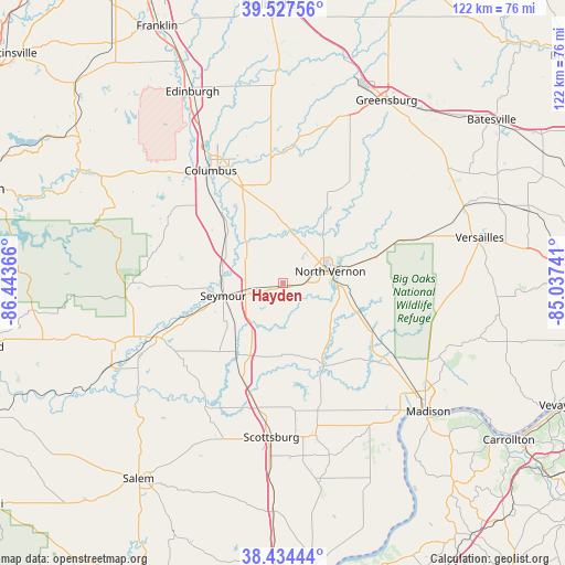
Hayden GPS coordinates[2]
38° 58' 59.196" North, 85° 44' 25.908" West
| Map corner | latitude | longitude |
|---|---|---|
| Upper-left | 39.52756°, | -86.44366° |
| Center: | 38.98311°, | -85.74053° |
| Lower-right: | 38.43444°, | -85.03741° |
| Map W x H: | 121.5×121.5 km | = 75.5×75.5mi |
| max Lat: | 71.29058° ⇑55% North |
| Hayden: | 38.98311° |
| min Lat: | ⇓45% South 19.06759° |
| min Long | Hayden | max Long |
| -171.73463° | -85.74053° | -66.98998° |
| W 53.6%⇐ | ⇒46.4% E |
Elevation
Elevation of Hayden is 193 m = 633 ft, and this is 101.8 m = 334 ft below average elevation for this country.
| Max E: |
3189 m = 10463 ft | 51.4% |
| Avg. | 294.8 m = 967 ft | |
| Hayden | 193 m = 633 ft | |
Min E: |
-60 m = -197 ft | 48.6% |
See also: United States elevation on elevation.city.
Geographical zone
Hayden is located in North temperate zone (between Tropic of Cancer and the Arctic Circle). Distance of this Northern Tropic circle is 1728.6 km =1074.1 mi to South.| Distance of | km | miles | from Hayden |
|---|---|---|---|
| North Pole | 5672.5 | 3524.7 | to North |
| Arctic Circle | 3066.7 | 1905.6 | to North |
| Tropic Cancer | 1728.6 | 1074.1 | to South |
| Equator | 4334.5 | 2693.3 | to South |


Nearby cities:
15 places around Hayden: (largest is in red/bold)
• Austin
25.7 km =16 mi,  193°
193°
• Brownstown
28.5 km =17.7 mi,  246°
246°
• Columbus
28.9 km =18 mi,  327°
327°
• Country Squire Lakes
6.8 km =4.2 mi,  32°
32°
• Crothersville
22.1 km =13.7 mi,  203°
203°
• Elizabethtown
18 km =11.2 mi,  339°
339°
• Hanover
37.8 km =23.5 mi,  142°
142°
• Hope
35.8 km =22.2 mi,  355°
355°
• Medora
41.1 km =25.5 mi,  244°
244°
• North Madison
38.2 km =23.7 mi,  128°
128°
• North Vernon
10.4 km =6.5 mi,  75°
75°
• Scottsburg
33.2 km =20.6 mi,  184°
184°
• Seymour
13.2 km =8.2 mi,  258°
258°
• Taylorsville
39.2 km =24.4 mi, 332°
• Westport
25.9 km =16.1 mi, 33°
Sources, notices
• [Note1] Compared only with cities in United States existing in our database
• [Src1] Map data: © OpenStreetMap contributors (CC-BY-SA)
• [Src2] Other city data from geonames.org with taken over terms of usage.
• [Src3] Geographical zone / Annual Mean Temperature by Robert A. Rohde @ Wikipedia
