Hope geodata
Hope (Indiana) is a populated place; located in United States in America/Indiana/Indianapolis (GMT-4) time zone. With population of 2,167 people, there are 11423 cities with bigger population in this country. Compared to other cities in United States, 52.2% of cities are located further ↑North; 53.5% of cities are located further ←West and 55.1% of cities have lower elevation than Hope. Note1
Administrative division(s):
- Level 1: Indiana
- Level 2: Bartholomew County
- Level 3: Township of Haw Creek


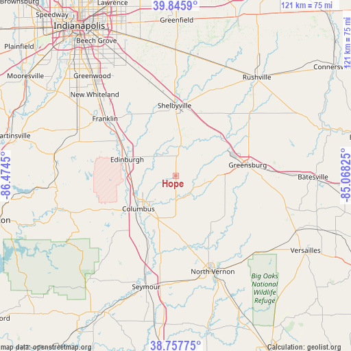
Hope GPS coordinates[2]
39° 18' 14.184" North, 85° 46' 16.932" West
| Map corner | latitude | longitude |
|---|---|---|
| Upper-left | 39.8459°, | -86.4745° |
| Center: | 39.30394°, | -85.77137° |
| Lower-right: | 38.75775°, | -85.06825° |
| Map W x H: | 121×121 km | = 75.2×75.2mi |
| max Lat: | 71.29058° ⇑52.2% North |
| Hope: | 39.30394° |
| min Lat: | ⇓47.8% South 19.06759° |
| min Long | Hope | max Long |
| -171.73463° | -85.77137° | -66.98998° |
| W 53.5%⇐ | ⇒46.5% E |
Elevation
Elevation of Hope is 219 m = 719 ft, and this is 75.8 m = 249 ft below average elevation for this country.
| Max E: |
3189 m = 10463 ft | 44.9% |
| Avg. | 294.8 m = 967 ft | |
| Hope | 219 m = 719 ft | |
Min E: |
-60 m = -197 ft | 55.1% |
See also: United States elevation on elevation.city.
Geographical zone
Hope is located in North temperate zone (between Tropic of Cancer and the Arctic Circle). Distance of this Northern Tropic circle is 1764.3 km =1096.3 mi to South.| Distance of | km | miles | from Hope |
|---|---|---|---|
| North Pole | 5636.9 | 3502.6 | to North |
| Arctic Circle | 3031 | 1883.4 | to North |
| Tropic Cancer | 1764.3 | 1096.3 | to South |
| Equator | 4370.2 | 2715.5 | to South |


Nearby cities:
15 places around Hope: (largest is in red/bold)
• Columbus
17.2 km =10.7 mi,  228°
228°
• Cordry Sweetwater Lakes
29.9 km =18.6 mi,  270°
270°
• Country Squire Lakes
30.6 km =19 mi,  168°
168°
• Edinburgh
17.7 km =11 mi,  288°
288°
• Elizabethtown
19.1 km =11.9 mi,  190°
190°
• Fairland
32.3 km =20.1 mi,  345°
345°
• Franklin
31.3 km =19.4 mi,  308°
308°
• Geneva
10.7 km =6.6 mi,  24°
24°
• Greensburg
25 km =15.5 mi,  81°
81°
• Princes Lakes
28.6 km =17.8 mi,  281°
281°
• Saint Paul
18.5 km =11.5 mi,  41°
41°
• Shelbyville
24.2 km =15 mi,  358°
358°
• Taylorsville
15.5 km =9.6 mi, 266°
• Waldron
18.9 km =11.7 mi,  28°
28°
• Westport
22.2 km =13.8 mi,  129°
129°
Sources, notices
• [Note1] Compared only with cities in United States existing in our database
• [Src1] Map data: © OpenStreetMap contributors (CC-BY-SA)
• [Src2] Other city data from geonames.org with taken over terms of usage.
• [Src3] Geographical zone / Annual Mean Temperature by Robert A. Rohde @ Wikipedia
