Loogootee geodata
Loogootee (Indiana) is a populated place; located in United States in America/Indiana/Vincennes (GMT-4) time zone. With population of 2,722 people, there are 10135 cities with bigger population in this country. Compared to other cities in United States, 57.6% of cities are located further ↑North; 50.5% of cities are located further ←West and 58% of cities have higher elevation than Loogootee. Note1


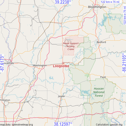
Loogootee GPS coordinates[2]
38° 40' 37.164" North, 86° 54' 51.012" West
| Map corner | latitude | longitude |
|---|---|---|
| Upper-left | 39.2238°, | -87.6173° |
| Center: | 38.67699°, | -86.91417° |
| Lower-right: | 38.12597°, | -86.21105° |
| Map W x H: | 122.1×122.1 km | = 75.9×75.9mi |
| max Lat: | 71.29058° ⇑57.6% North |
| Loogootee: | 38.67699° |
| min Lat: | ⇓42.4% South 19.06759° |
| min Long | Loogootee | max Long |
| -171.73463° | -86.91417° | -66.98998° |
| W 50.5%⇐ | ⇒49.5% E |
Elevation
Elevation of Loogootee is 165 m = 541 ft, and this is 129.8 m = 426 ft below average elevation for this country.
| Max E: |
3189 m = 10463 ft | 58% |
| Avg. | 294.8 m = 967 ft | |
| Loogootee | 165 m = 541 ft | |
Min E: |
-60 m = -197 ft | 42% |
See also: United States elevation on elevation.city.
Geographical zone
Loogootee is located in North temperate zone (between Tropic of Cancer and the Arctic Circle). Distance of this Northern Tropic circle is 1694.6 km =1053 mi to South.| Distance of | km | miles | from Loogootee |
|---|---|---|---|
| North Pole | 5706.6 | 3545.9 | to North |
| Arctic Circle | 3100.7 | 1926.7 | to North |
| Tropic Cancer | 1694.6 | 1053 | to South |
| Equator | 4300.5 | 2672.2 | to South |


Nearby cities:
15 places around Loogootee: (largest is in red/bold)
• Bicknell
35.8 km =22.2 mi,  287°
287°
• Bloomfield
39 km =24.2 mi,  357°
357°
• Elnora
26.9 km =16.7 mi,  326°
326°
• Freelandville
39.9 km =24.8 mi,  301°
301°
• French Lick
29.3 km =18.2 mi,  119°
119°
• Jasper
31.8 km =19.8 mi,  182°
182°
• Lyons
37.6 km =23.4 mi,  337°
337°
• Mitchell
38.7 km =24 mi,  80°
80°
• Monroe City
38.8 km =24.1 mi,  259°
259°
• Odon
19.6 km =12.2 mi, 340°
• Orleans
40.2 km =25 mi,  92°
92°
• Petersburg
37.8 km =23.5 mi,  237°
237°
• Shoals
10.7 km =6.6 mi,  96°
96°
• Washington
22.5 km =14 mi, 264°
• West Baden Springs
29.1 km =18.1 mi, 115°
Sources, notices
• [Note1] Compared only with cities in United States existing in our database
• [Src1] Map data: © OpenStreetMap contributors (CC-BY-SA)
• [Src2] Other city data from geonames.org with taken over terms of usage.
• [Src3] Geographical zone / Annual Mean Temperature by Robert A. Rohde @ Wikipedia
