Bicknell geodata
Bicknell (Indiana) is a populated place; located in United States in America/Indiana/Vincennes (GMT-4) time zone. With population of 2,892 people, there are 9818 cities with bigger population in this country. Compared to other cities in United States, 56.8% of cities are located further ↑North; 50.4% of cities are located further →East and 59.7% of cities have higher elevation than Bicknell. Note1


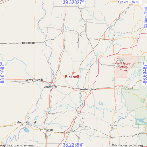
Bicknell GPS coordinates[2]
38° 46' 27.156" North, 87° 18' 28.044" West
| Map corner | latitude | longitude |
|---|---|---|
| Upper-left | 39.32027°, | -88.01092° |
| Center: | 38.77421°, | -87.30779° |
| Lower-right: | 38.22394°, | -86.60467° |
| Map W x H: | 121.9×121.9 km | = 75.7×75.7mi |
| max Lat: | 71.29058° ⇑56.8% North |
| Bicknell: | 38.77421° |
| min Lat: | ⇓43.2% South 19.06759° |
| min Long | Bicknell | max Long |
| -171.73463° | -87.30779° | -66.98998° |
| W 49.6%⇐ | ⇒50.4% E |
Elevation
Elevation of Bicknell is 156 m = 512 ft, and this is 138.8 m = 455 ft below average elevation for this country.
| Max E: |
3189 m = 10463 ft | 59.7% |
| Avg. | 294.8 m = 967 ft | |
| Bicknell | 156 m = 512 ft | |
Min E: |
-60 m = -197 ft | 40.3% |
See also: United States elevation on elevation.city.
Geographical zone
Bicknell is located in North temperate zone (between Tropic of Cancer and the Arctic Circle). Distance of this Northern Tropic circle is 1705.4 km =1059.7 mi to South.| Distance of | km | miles | from Bicknell |
|---|---|---|---|
| North Pole | 5695.8 | 3539.2 | to North |
| Arctic Circle | 3089.9 | 1920 | to North |
| Tropic Cancer | 1705.4 | 1059.7 | to South |
| Equator | 4311.3 | 2678.9 | to South |


Nearby cities:
15 places around Bicknell: (largest is in red/bold)
• Carlisle
23.2 km =14.4 mi,  338°
338°
• Dugger
33.1 km =20.6 mi,  6°
6°
• Elnora
22.4 km =13.9 mi,  58°
58°
• Freelandville
10.1 km =6.3 mi,  0°
0°
• Lawrenceville
32.8 km =20.4 mi,  261°
261°
• Linton
31.5 km =19.6 mi,  22°
22°
• Loogootee
35.8 km =22.2 mi,  107°
107°
• Lyons
30.9 km =19.2 mi,  39°
39°
• Monroe City
18.1 km =11.2 mi,  192°
192°
• Oaktown
15.8 km =9.8 mi,  312°
312°
• Odon
28.5 km =17.7 mi,  74°
74°
• Petersburg
31.5 km =19.6 mi,  175°
175°
• Saint Francisville
35.8 km =22.2 mi,  235°
235°
• Vincennes
22 km =13.7 mi, 240°
• Washington
17.3 km =10.7 mi,  137°
137°
Sources, notices
• [Note1] Compared only with cities in United States existing in our database
• [Src1] Map data: © OpenStreetMap contributors (CC-BY-SA)
• [Src2] Other city data from geonames.org with taken over terms of usage.
• [Src3] Geographical zone / Annual Mean Temperature by Robert A. Rohde @ Wikipedia
