Jasper geodata
Jasper (Indiana) is a seat of a second-order administrative division; located in United States in America/Indiana/Vincennes (GMT-4) time zone. With population of 15,451 people, there are 3154 cities with bigger population in this country. Compared to other cities in United States, 59.4% of cities are located further ↑North; 50.4% of cities are located further ←West and 61.7% of cities have higher elevation than Jasper. Note1


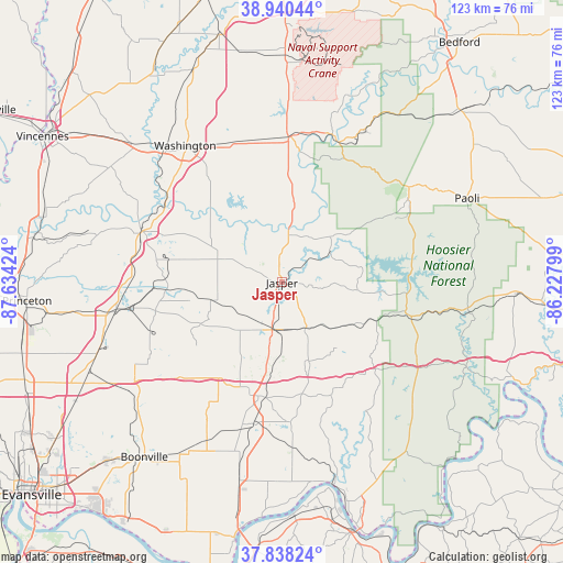
Jasper GPS coordinates[2]
38° 23' 29.184" North, 86° 55' 51.996" West
| Map corner | latitude | longitude |
|---|---|---|
| Upper-left | 38.94044°, | -87.63424° |
| Center: | 38.39144°, | -86.93111° |
| Lower-right: | 37.83824°, | -86.22799° |
| Map W x H: | 122.6×122.6 km | = 76.2×76.2mi |
| max Lat: | 71.29058° ⇑59.4% North |
| Jasper: | 38.39144° |
| min Lat: | ⇓40.6% South 19.06759° |
| min Long | Jasper | max Long |
| -171.73463° | -86.93111° | -66.98998° |
| W 50.4%⇐ | ⇒49.6% E |
Elevation
Elevation of Jasper is 146 m = 479 ft, and this is 148.8 m = 488 ft below average elevation for this country.
| Max E: |
3189 m = 10463 ft | 61.7% |
| Avg. | 294.8 m = 967 ft | |
| Jasper | 146 m = 479 ft | |
Min E: |
-60 m = -197 ft | 38.3% |
See also: United States elevation on elevation.city.
Geographical zone
Jasper is located in North temperate zone (between Tropic of Cancer and the Arctic Circle). Distance of this Northern Tropic circle is 1662.8 km =1033.2 mi to South.| Distance of | km | miles | from Jasper |
|---|---|---|---|
| North Pole | 5738.3 | 3565.6 | to North |
| Arctic Circle | 3132.4 | 1946.4 | to North |
| Tropic Cancer | 1662.8 | 1033.2 | to South |
| Equator | 4268.7 | 2652.4 | to South |


Nearby cities:
15 places around Jasper: (largest is in red/bold)
• Dale
25.3 km =15.7 mi,  191°
191°
• Ferdinand
19.6 km =12.2 mi,  162°
162°
• French Lick
32.3 km =20.1 mi,  57°
57°
• Holland
18.6 km =11.6 mi,  209°
209°
• Huntingburg
10.5 km =6.5 mi, 191°
• Loogootee
31.8 km =19.8 mi,  2°
2°
• Lynnville
38.6 km =24 mi,  235°
235°
• Oakland City
36.6 km =22.7 mi,  260°
260°
• Petersburg
32.3 km =20.1 mi,  290°
290°
• Saint Meinrad
26.7 km =16.6 mi, 156°
• Santa Claus
30.2 km =18.8 mi,  177°
177°
• Shoals
32.9 km =20.4 mi,  21°
21°
• Washington
36.4 km =22.6 mi,  324°
324°
• West Baden Springs
33.9 km =21.1 mi, 55°
• Winslow
24.6 km =15.3 mi,  267°
267°
Sources, notices
• [Note1] Compared only with cities in United States existing in our database
• [Src1] Map data: © OpenStreetMap contributors (CC-BY-SA)
• [Src2] Other city data from geonames.org with taken over terms of usage.
• [Src3] Geographical zone / Annual Mean Temperature by Robert A. Rohde @ Wikipedia
