New Castle geodata
New Castle (Indiana) is a seat of a second-order administrative division; located in United States in America/Indiana/Indianapolis (GMT-4) time zone. With population of 17,621 people, there are 2831 cities with bigger population in this country. Compared to other cities in United States, 52.8% of cities are located further ↓South; 54.9% of cities are located further ←West and 76.6% of cities have lower elevation than New Castle. Note1


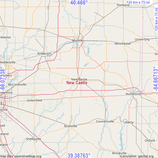
New Castle GPS coordinates[2]
39° 55' 44.184" North, 85° 22' 12.9" West
| Map corner | latitude | longitude |
|---|---|---|
| Upper-left | 40.466°, | -86.07338° |
| Center: | 39.92894°, | -85.37025° |
| Lower-right: | 39.38763°, | -84.66713° |
| Map W x H: | 119.9×119.9 km | = 74.5×74.5mi |
| max Lat: | 71.29058° ⇑47.2% North |
| New Castle: | 39.92894° |
| min Lat: | ⇓52.8% South 19.06759° |
| min Long | New Castle | max Long |
| -171.73463° | -85.37025° | -66.98998° |
| W 54.9%⇐ | ⇒45.1% E |
Elevation
Elevation of New Castle is 325 m = 1066 ft, and this is 30.2 m = 99 ft above average elevation for this country.
| Max E: |
3189 m = 10463 ft | 23.4% |
| New Castle | 325 m 1066 ft | |
| Avg. | 294.8 m = 967 ft | |
Min E: |
-60 m = -197 ft | 76.6% |
See also: United States elevation on elevation.city.
Geographical zone
New Castle is located in North temperate zone (between Tropic of Cancer and the Arctic Circle). Distance of this Northern Tropic circle is 1833.8 km =1139.5 mi to South.| Distance of | km | miles | from New Castle |
|---|---|---|---|
| North Pole | 5567.4 | 3459.4 | to North |
| Arctic Circle | 2961.5 | 1840.2 | to North |
| Tropic Cancer | 1833.8 | 1139.5 | to South |
| Equator | 4439.7 | 2758.7 | to South |


Nearby cities:
15 places around New Castle: (largest is in red/bold)
• Cambridge City
21.3 km =13.2 mi,  127°
127°
• Carthage
27.3 km =17 mi,  219°
219°
• Chesterfield
28.1 km =17.5 mi,  316°
316°
• Daleville
26.7 km =16.6 mi, 323°
• Dublin
18.9 km =11.7 mi, 133°
• Hagerstown
17.9 km =11.1 mi,  96°
96°
• Knightstown
19.9 km =12.4 mi, 221°
• Markleville
21.5 km =13.4 mi,  284°
284°
• Middletown
20.1 km =12.5 mi, 315°
• Muncie
29.4 km =18.3 mi,  357°
357°
• Parker City
32.2 km =20 mi,  26°
26°
• Selma
30.5 km =19 mi,  16°
16°
• Shirley
18.1 km =11.2 mi,  256°
256°
• Spiceland
11.6 km =7.2 mi,  210°
210°
• Yorktown
29.2 km =18.1 mi,  338°
338°
Sources, notices
• [Note1] Compared only with cities in United States existing in our database
• [Src1] Map data: © OpenStreetMap contributors (CC-BY-SA)
• [Src2] Other city data from geonames.org with taken over terms of usage.
• [Src3] Geographical zone / Annual Mean Temperature by Robert A. Rohde @ Wikipedia
