Spiceland geodata
Spiceland (Indiana) is a populated place; located in United States in America/Indiana/Indianapolis (GMT-4) time zone. With population of 868 people, there are 17212 cities with bigger population in this country. Compared to other cities in United States, 51.9% of cities are located further ↓South; 54.8% of cities are located further ←West and 76.3% of cities have lower elevation than Spiceland. Note1


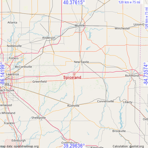
Spiceland GPS coordinates[2]
39° 50' 18.168" North, 85° 26' 19.896" West
| Map corner | latitude | longitude |
|---|---|---|
| Upper-left | 40.37615°, | -86.14199° |
| Center: | 39.83838°, | -85.43886° |
| Lower-right: | 39.29636°, | -84.73574° |
| Map W x H: | 120.1×120.1 km | = 74.6×74.6mi |
| max Lat: | 71.29058° ⇑48.1% North |
| Spiceland: | 39.83838° |
| min Lat: | ⇓51.9% South 19.06759° |
| min Long | Spiceland | max Long |
| -171.73463° | -85.43886° | -66.98998° |
| W 54.8%⇐ | ⇒45.2% E |
Elevation
Elevation of Spiceland is 322 m = 1056 ft, and this is 27.2 m = 89 ft above average elevation for this country.
| Max E: |
3189 m = 10463 ft | 23.7% |
| Spiceland | 322 m 1056 ft | |
| Avg. | 294.8 m = 967 ft | |
Min E: |
-60 m = -197 ft | 76.3% |
See also: United States elevation on elevation.city.
Geographical zone
Spiceland is located in North temperate zone (between Tropic of Cancer and the Arctic Circle). Distance of this Northern Tropic circle is 1823.7 km =1133.2 mi to South.| Distance of | km | miles | from Spiceland |
|---|---|---|---|
| North Pole | 5577.4 | 3465.6 | to North |
| Arctic Circle | 2971.6 | 1846.5 | to North |
| Tropic Cancer | 1823.7 | 1133.2 | to South |
| Equator | 4429.6 | 2752.4 | to South |


Nearby cities:
15 places around Spiceland: (largest is in red/bold)
• Cambridge City
23 km =14.3 mi,  97°
97°
• Carthage
15.9 km =9.9 mi,  225°
225°
• Chesterfield
33.3 km =20.7 mi,  336°
336°
• Daleville
33 km =20.5 mi, 342°
• Dublin
19.9 km =12.4 mi, 98°
• Greenfield
28.8 km =17.9 mi,  258°
258°
• Hagerstown
25 km =15.5 mi,  71°
71°
• Knightstown
8.9 km =5.5 mi,  237°
237°
• Markleville
21.6 km =13.4 mi,  315°
315°
• Middletown
25.7 km =16 mi, 340°
• Morristown
28.8 km =17.9 mi, 230°
• New Castle
11.6 km =7.2 mi,  30°
30°
• Pendleton
31.7 km =19.7 mi,  303°
303°
• Rushville
25.5 km =15.8 mi,  181°
181°
• Shirley
13.2 km =8.2 mi, 296°
Sources, notices
• [Note1] Compared only with cities in United States existing in our database
• [Src1] Map data: © OpenStreetMap contributors (CC-BY-SA)
• [Src2] Other city data from geonames.org with taken over terms of usage.
• [Src3] Geographical zone / Annual Mean Temperature by Robert A. Rohde @ Wikipedia
