Sellersburg geodata
Sellersburg (Indiana) is a populated place; located in United States in America/Kentucky/Louisville (GMT-4) time zone. With population of 8,659 people, there are 4944 cities with bigger population in this country. Compared to other cities in United States, 59.4% of cities are located further ↑North; 53.6% of cities are located further ←West and 60.7% of cities have higher elevation than Sellersburg. Note1
Administrative division(s):
- Level 1: Indiana
- Level 2: Clark County
- Level 3: Township of Silver Creek


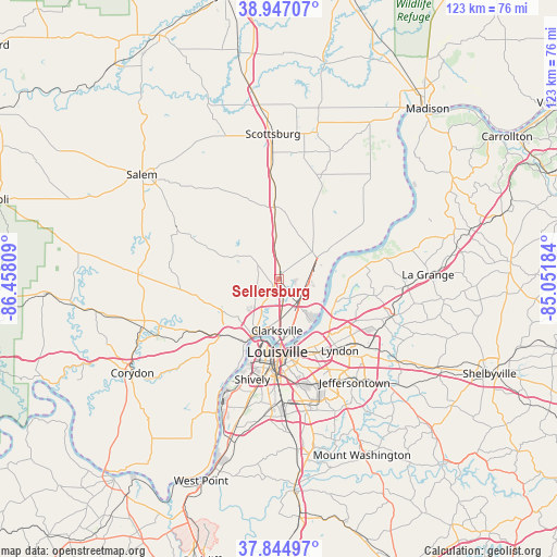
Sellersburg GPS coordinates[2]
38° 23' 53.232" North, 85° 45' 17.856" West
| Map corner | latitude | longitude |
|---|---|---|
| Upper-left | 38.94707°, | -86.45809° |
| Center: | 38.39812°, | -85.75496° |
| Lower-right: | 37.84497°, | -85.05184° |
| Map W x H: | 122.5×122.5 km | = 76.1×76.1mi |
| max Lat: | 71.29058° ⇑59.4% North |
| Sellersburg: | 38.39812° |
| min Lat: | ⇓40.6% South 19.06759° |
| min Long | Sellersburg | max Long |
| -171.73463° | -85.75496° | -66.98998° |
| W 53.6%⇐ | ⇒46.4% E |
Elevation
Elevation of Sellersburg is 151 m = 495 ft, and this is 143.8 m = 472 ft below average elevation for this country.
| Max E: |
3189 m = 10463 ft | 60.7% |
| Avg. | 294.8 m = 967 ft | |
| Sellersburg | 151 m = 495 ft | |
Min E: |
-60 m = -197 ft | 39.3% |
See also: United States elevation on elevation.city.
Geographical zone
Sellersburg is located in North temperate zone (between Tropic of Cancer and the Arctic Circle). Distance of this Northern Tropic circle is 1663.6 km =1033.7 mi to South.| Distance of | km | miles | from Sellersburg |
|---|---|---|---|
| North Pole | 5737.6 | 3565.2 | to North |
| Arctic Circle | 3131.7 | 1945.9 | to North |
| Tropic Cancer | 1663.6 | 1033.7 | to South |
| Equator | 4269.5 | 2652.9 | to South |


Nearby cities:
15 places around Sellersburg: (largest is in red/bold)
• Charlestown
9.6 km =6 mi,  50°
50°
• Clarksville
11.3 km =7 mi,  182°
182°
• Glenview
13.5 km =8.4 mi,  137°
137°
• Goshen
15.8 km =9.8 mi,  87°
87°
• Green Spring
15.3 km =9.5 mi,  126°
126°
• Henryville
16 km =9.9 mi,  356°
356°
• Jeffersonville
13.5 km =8.4 mi,  173°
173°
• Louisville
16 km =9.9 mi, 181°
• Memphis
9.5 km =5.9 mi, 356°
• New Albany
13.9 km =8.6 mi,  205°
205°
• Northfield
15.9 km =9.9 mi, 141°
• Oak Park
11.5 km =7.1 mi,  153°
153°
• Prospect
13.5 km =8.4 mi,  115°
115°
• Utica
11.4 km =7.1 mi, 129°
• Winding Falls
16 km =9.9 mi, 142°
Sources, notices
• [Note1] Compared only with cities in United States existing in our database
• [Src1] Map data: © OpenStreetMap contributors (CC-BY-SA)
• [Src2] Other city data from geonames.org with taken over terms of usage.
• [Src3] Geographical zone / Annual Mean Temperature by Robert A. Rohde @ Wikipedia
