New Albany geodata
New Albany (Indiana) is a seat of a second-order administrative division; located in United States in America/Kentucky/Louisville (GMT-4) time zone. With population of 36,732 people, there are 1327 cities with bigger population in this country. Compared to other cities in United States, 60% of cities are located further ↑North; 53.4% of cities are located further ←West and 62.6% of cities have higher elevation than New Albany. Note1


New Albany GPS coordinates[2]
38° 17' 8.232" North, 85° 49' 26.868" West
| Map corner | latitude | longitude |
|---|---|---|
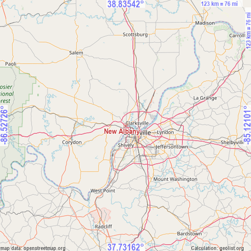
| Upper-left | 38.83542°, | -86.52726° |
| Center: | 38.28562°, | -85.82413° |
| Lower-right: | 37.73162°, | -85.12101° |
| Map W x H: | 122.7×122.7 km | = 76.2×76.2mi |
| max Lat: | 71.29058° ⇑60% North |
| New Albany: | 38.28562° |
| min Lat: | ⇓40% South 19.06759° |
| min Long | New Albany | max Long |
| -171.73463° | -85.82413° | -66.98998° |
| W 53.4%⇐ | ⇒46.6% E |
Elevation
Elevation of New Albany is 141 m = 463 ft, and this is 153.8 m = 505 ft below average elevation for this country.
| Max E: |
3189 m = 10463 ft | 62.6% |
| Avg. | 294.8 m = 967 ft | |
| New Albany | 141 m = 463 ft | |
Min E: |
-60 m = -197 ft | 37.4% |
See also: United States elevation on elevation.city.
Geographical zone
New Albany is located in North temperate zone (between Tropic of Cancer and the Arctic Circle). Distance of this Northern Tropic circle is 1651 km =1025.9 mi to South.| Distance of | km | miles | from New Albany |
|---|---|---|---|
| North Pole | 5750.1 | 3572.9 | to North |
| Arctic Circle | 3144.2 | 1953.7 | to North |
| Tropic Cancer | 1651 | 1025.9 | to South |
| Equator | 4257 | 2645.2 | to South |


Nearby cities:
15 places around New Albany: (largest is in red/bold)
• Audubon Park
12.5 km =7.8 mi,  136°
136°
• Clarksville
5.7 km =3.5 mi,  77°
77°
• Galena
12.6 km =7.8 mi,  305°
305°
• Georgetown
13.2 km =8.2 mi,  274°
274°
• Indian Hills
14.2 km =8.8 mi,  95°
95°
• Jeffersonville
7.6 km =4.7 mi, 96°
• Louisville
6.6 km =4.1 mi,  121°
121°
• Oak Park
11.4 km =7.1 mi, 78°
• Parkway Village
10.9 km =6.8 mi, 137°
• Rolling Fields
13.5 km =8.4 mi, 98°
• Saint Dennis
11 km =6.8 mi,  189°
189°
• Sellersburg
13.9 km =8.6 mi,  25°
25°
• Seneca Gardens
14.3 km =8.9 mi, 116°
• Shively
9.5 km =5.9 mi,  179°
179°
• Strathmoor Village
14.5 km =9 mi, 118°
Sources, notices
• [Note1] Compared only with cities in United States existing in our database
• [Src1] Map data: © OpenStreetMap contributors (CC-BY-SA)
• [Src2] Other city data from geonames.org with taken over terms of usage.
• [Src3] Geographical zone / Annual Mean Temperature by Robert A. Rohde @ Wikipedia
