Buhler geodata
Buhler (Kansas) is a populated place; located in United States in America/Chicago (GMT-5) time zone. With population of 1,332 people, there are 14424 cities with bigger population in this country. Compared to other cities in United States, 61% of cities are located further ↑North; 77.9% of cities are located further →East and 86.7% of cities have lower elevation than Buhler. Note1


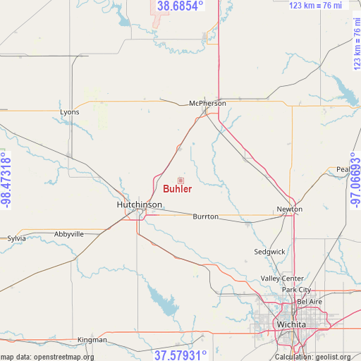
Buhler GPS coordinates[2]
38° 8' 4.02" North, 97° 46' 12.18" West
| Map corner | latitude | longitude |
|---|---|---|
| Upper-left | 38.6854°, | -98.47318° |
| Center: | 38.13445°, | -97.77005° |
| Lower-right: | 37.57931°, | -97.06693° |
| Map W x H: | 123×123 km | = 76.4×76.4mi |
| max Lat: | 71.29058° ⇑61% North |
| Buhler: | 38.13445° |
| min Lat: | ⇓39% South 19.06759° |
| min Long | Buhler | max Long |
| -171.73463° | -97.77005° | -66.98998° |
| W 22.1%⇐ | ⇒77.9% E |
Elevation
Elevation of Buhler is 459 m = 1506 ft, and this is 164.2 m = 539 ft above average elevation for this country.
| Max E: |
3189 m = 10463 ft | 13.3% |
| Buhler | 459 m 1506 ft | |
| Avg. | 294.8 m = 967 ft | |
Min E: |
-60 m = -197 ft | 86.7% |
See also: United States elevation on elevation.city.
Geographical zone
Buhler is located in North temperate zone (between Tropic of Cancer and the Arctic Circle). Distance of this Northern Tropic circle is 1634.2 km =1015.4 mi to South.| Distance of | km | miles | from Buhler |
|---|---|---|---|
| North Pole | 5766.9 | 3583.4 | to North |
| Arctic Circle | 3161 | 1964.2 | to North |
| Tropic Cancer | 1634.2 | 1015.4 | to South |
| Equator | 4240.2 | 2634.7 | to South |


Nearby cities:
15 places around Buhler: (largest is in red/bold)
• Bentley
35.4 km =22 mi,  141°
141°
• Burrton
15.1 km =9.4 mi, 144°
• Galva
34.2 km =21.3 mi,  36°
36°
• Halstead
27.2 km =16.9 mi,  122°
122°
• Haven
26.2 km =16.3 mi,  182°
182°
• Hesston
29.6 km =18.4 mi,  89°
89°
• Hutchinson
16.2 km =10.1 mi,  239°
239°
• Inman
10.8 km =6.7 mi,  358°
358°
• Little River
36.1 km =22.4 mi,  324°
324°
• McPherson
27.9 km =17.3 mi,  19°
19°
• Moundridge
23.2 km =14.4 mi,  70°
70°
• Mount Hope
31 km =19.3 mi,  162°
162°
• Nickerson
27.5 km =17.1 mi,  272°
272°
• North Newton
37.8 km =23.5 mi,  100°
100°
• South Hutchinson
19 km =11.8 mi,  231°
231°
Sources, notices
• [Note1] Compared only with cities in United States existing in our database
• [Src1] Map data: © OpenStreetMap contributors (CC-BY-SA)
• [Src2] Other city data from geonames.org with taken over terms of usage.
• [Src3] Geographical zone / Annual Mean Temperature by Robert A. Rohde @ Wikipedia
