Nickerson geodata
Nickerson (Kansas) is a populated place; located in United States in America/Chicago (GMT-5) time zone. With population of 1,036 people, there are 16048 cities with bigger population in this country. Compared to other cities in United States, 60.9% of cities are located further ↑North; 78.6% of cities are located further →East and 87.6% of cities have lower elevation than Nickerson. Note1


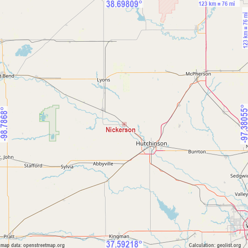
Nickerson GPS coordinates[2]
38° 8' 50.028" North, 98° 5' 1.212" West
| Map corner | latitude | longitude |
|---|---|---|
| Upper-left | 38.69809°, | -98.7868° |
| Center: | 38.14723°, | -98.08367° |
| Lower-right: | 37.59218°, | -97.38055° |
| Map W x H: | 123×123 km | = 76.4×76.4mi |
| max Lat: | 71.29058° ⇑60.9% North |
| Nickerson: | 38.14723° |
| min Lat: | ⇓39.1% South 19.06759° |
| min Long | Nickerson | max Long |
| -171.73463° | -98.08367° | -66.98998° |
| W 21.4%⇐ | ⇒78.6% E |
Elevation
Elevation of Nickerson is 491 m = 1611 ft, and this is 196.2 m = 644 ft above average elevation for this country.
| Max E: |
3189 m = 10463 ft | 12.4% |
| Nickerson | 491 m 1611 ft | |
| Avg. | 294.8 m = 967 ft | |
Min E: |
-60 m = -197 ft | 87.6% |
See also: United States elevation on elevation.city.
Geographical zone
Nickerson is located in North temperate zone (between Tropic of Cancer and the Arctic Circle). Distance of this Northern Tropic circle is 1635.7 km =1016.4 mi to South.| Distance of | km | miles | from Nickerson |
|---|---|---|---|
| North Pole | 5765.5 | 3582.5 | to North |
| Arctic Circle | 3159.6 | 1963.3 | to North |
| Tropic Cancer | 1635.7 | 1016.4 | to South |
| Equator | 4241.6 | 2635.6 | to South |


Nearby cities:
15 places around Nickerson: (largest is in red/bold)
• Buhler
27.5 km =17.1 mi,  92°
92°
• Burrton
38.7 km =24 mi,  110°
110°
• Ellinwood
49.2 km =30.6 mi,  298°
298°
• Haven
38.2 km =23.7 mi,  136°
136°
• Hutchinson
16.5 km =10.3 mi,  125°
125°
• Inman
28.7 km =17.8 mi,  70°
70°
• Little River
28.6 km =17.8 mi,  12°
12°
• Lyons
24.3 km =15.1 mi,  334°
334°
• McPherson
44.3 km =27.5 mi,  55°
55°
• Moundridge
49.7 km =30.9 mi,  82°
82°
• Mount Hope
48 km =29.8 mi, 130°
• Pretty Prairie
41.2 km =25.6 mi,  172°
172°
• South Hutchinson
18.2 km =11.3 mi, 136°
• Stafford
49.7 km =30.9 mi,  245°
245°
• Sterling
12.8 km =8 mi, 302°
Sources, notices
• [Note1] Compared only with cities in United States existing in our database
• [Src1] Map data: © OpenStreetMap contributors (CC-BY-SA)
• [Src2] Other city data from geonames.org with taken over terms of usage.
• [Src3] Geographical zone / Annual Mean Temperature by Robert A. Rohde @ Wikipedia
