Hutchinson geodata
Hutchinson (Kansas) is a seat of a second-order administrative division; located in United States in America/Chicago (GMT-5) time zone. With population of 41,569 people, there are 1151 cities with bigger population in this country. Compared to other cities in United States, 61.3% of cities are located further ↑North; 78.3% of cities are located further →East and 87.1% of cities have lower elevation than Hutchinson. Note1


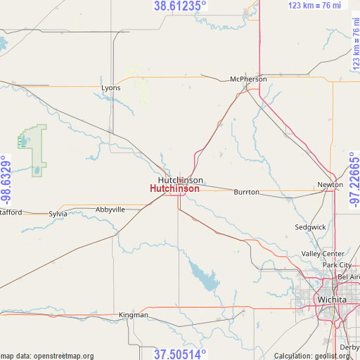
Hutchinson GPS coordinates[2]
38° 3' 39.024" North, 97° 55' 47.172" West
| Map corner | latitude | longitude |
|---|---|---|
| Upper-left | 38.61235°, | -98.6329° |
| Center: | 38.06084°, | -97.92977° |
| Lower-right: | 37.50514°, | -97.22665° |
| Map W x H: | 123.1×123.1 km | = 76.5×76.5mi |
| max Lat: | 71.29058° ⇑61.3% North |
| Hutchinson: | 38.06084° |
| min Lat: | ⇓38.7% South 19.06759° |
| min Long | Hutchinson | max Long |
| -171.73463° | -97.92977° | -66.98998° |
| W 21.7%⇐ | ⇒78.3% E |
Elevation
Elevation of Hutchinson is 473 m = 1552 ft, and this is 178.2 m = 585 ft above average elevation for this country.
| Max E: |
3189 m = 10463 ft | 12.9% |
| Hutchinson | 473 m 1552 ft | |
| Avg. | 294.8 m = 967 ft | |
Min E: |
-60 m = -197 ft | 87.1% |
See also: Hutchinson elevation on elevation.city.
Geographical zone
Hutchinson is located in North temperate zone (between Tropic of Cancer and the Arctic Circle). Distance of this Northern Tropic circle is 1626 km =1010.3 mi to South.| Distance of | km | miles | from Hutchinson |
|---|---|---|---|
| North Pole | 5775.1 | 3588.5 | to North |
| Arctic Circle | 3169.2 | 1969.2 | to North |
| Tropic Cancer | 1626 | 1010.3 | to South |
| Equator | 4232 | 2629.6 | to South |


Nearby cities:
15 places around Hutchinson: (largest is in red/bold)
• Andale
40 km =24.9 mi,  138°
138°
• Bentley
41.1 km =25.5 mi,  118°
118°
• Buhler
16.2 km =10.1 mi,  59°
59°
• Burrton
23.1 km =14.4 mi,  100°
100°
• Halstead
37.5 km =23.3 mi, 100°
• Haven
22.1 km =13.7 mi, 144°
• Inman
23.4 km =14.5 mi,  35°
35°
• Little River
38.2 km =23.7 mi,  349°
349°
• Lyons
39.5 km =24.5 mi,  323°
323°
• Moundridge
39.2 km =24.4 mi,  66°
66°
• Mount Hope
31.5 km =19.6 mi,  132°
132°
• Nickerson
16.5 km =10.3 mi,  305°
305°
• Pretty Prairie
32.2 km =20 mi,  194°
194°
• South Hutchinson
3.8 km =2.4 mi, 194°
• Sterling
29.4 km =18.3 mi,  304°
304°
Sources, notices
• [Note1] Compared only with cities in United States existing in our database
• [Src1] Map data: © OpenStreetMap contributors (CC-BY-SA)
• [Src2] Other city data from geonames.org with taken over terms of usage.
• [Src3] Geographical zone / Annual Mean Temperature by Robert A. Rohde @ Wikipedia
