Cheney geodata
Cheney (Kansas) is a populated place; located in United States in America/Chicago (GMT-5) time zone. With population of 2,159 people, there are 11444 cities with bigger population in this country. Compared to other cities in United States, 63.5% of cities are located further ↑North; 77.9% of cities are located further →East and 85.3% of cities have lower elevation than Cheney. Note1


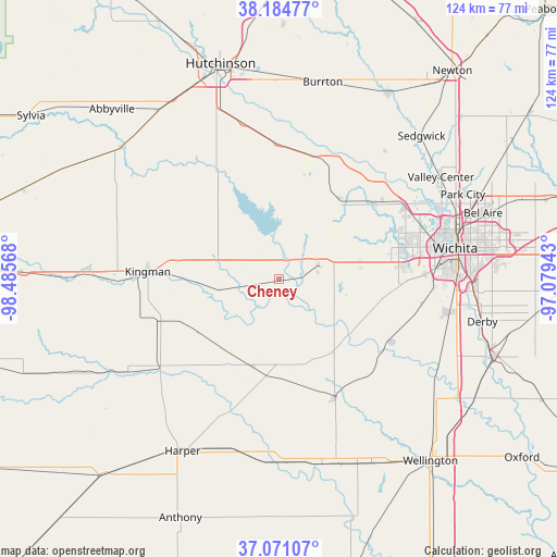
Cheney GPS coordinates[2]
37° 37' 48.036" North, 97° 46' 57.18" West
| Map corner | latitude | longitude |
|---|---|---|
| Upper-left | 38.18477°, | -98.48568° |
| Center: | 37.63001°, | -97.78255° |
| Lower-right: | 37.07107°, | -97.07943° |
| Map W x H: | 123.8×123.8 km | = 76.9×76.9mi |
| max Lat: | 71.29058° ⇑63.5% North |
| Cheney: | 37.63001° |
| min Lat: | ⇓36.5% South 19.06759° |
| min Long | Cheney | max Long |
| -171.73463° | -97.78255° | -66.98998° |
| W 22.1%⇐ | ⇒77.9% E |
Elevation
Elevation of Cheney is 430 m = 1411 ft, and this is 135.2 m = 444 ft above average elevation for this country.
| Max E: |
3189 m = 10463 ft | 14.7% |
| Cheney | 430 m 1411 ft | |
| Avg. | 294.8 m = 967 ft | |
Min E: |
-60 m = -197 ft | 85.3% |
See also: United States elevation on elevation.city.
Geographical zone
Cheney is located in North temperate zone (between Tropic of Cancer and the Arctic Circle). Distance of this Northern Tropic circle is 1578.1 km =980.6 mi to South.| Distance of | km | miles | from Cheney |
|---|---|---|---|
| North Pole | 5823 | 3618.2 | to North |
| Arctic Circle | 3217.1 | 1999 | to North |
| Tropic Cancer | 1578.1 | 980.6 | to South |
| Equator | 4184.1 | 2599.9 | to South |


Nearby cities:
15 places around Cheney: (largest is in red/bold)
• Andale
22.4 km =13.9 mi,  37°
37°
• Bentley
36.8 km =22.9 mi, 39°
• Clearwater
28.3 km =17.6 mi,  119°
119°
• Colwich
27.3 km =17 mi,  52°
52°
• Conway Springs
29.4 km =18.3 mi,  155°
155°
• Garden Plain
9.3 km =5.8 mi,  70°
70°
• Goddard
18.5 km =11.5 mi,  79°
79°
• Haven
29.9 km =18.6 mi,  359°
359°
• Haysville
38.6 km =24 mi,  100°
100°
• Kingman
29.2 km =18.1 mi,  273°
273°
• Maize
32.3 km =20.1 mi,  59°
59°
• Mount Hope
28.5 km =17.7 mi,  21°
21°
• Pretty Prairie
26.7 km =16.6 mi,  308°
308°
• Saint Marys
15.2 km =9.4 mi, 55°
• Wichita
39.8 km =24.7 mi, 79°
Sources, notices
• [Note1] Compared only with cities in United States existing in our database
• [Src1] Map data: © OpenStreetMap contributors (CC-BY-SA)
• [Src2] Other city data from geonames.org with taken over terms of usage.
• [Src3] Geographical zone / Annual Mean Temperature by Robert A. Rohde @ Wikipedia
