Goddard geodata
Goddard (Kansas) is a populated place; located in United States in America/Chicago (GMT-5) time zone. With population of 4,719 people, there are 7421 cities with bigger population in this country. Compared to other cities in United States, 63.4% of cities are located further ↑North; 77.3% of cities are located further →East and 86.4% of cities have lower elevation than Goddard. Note1


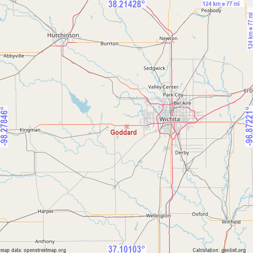
Goddard GPS coordinates[2]
37° 39' 35.064" North, 97° 34' 31.188" West
| Map corner | latitude | longitude |
|---|---|---|
| Upper-left | 38.21428°, | -98.27846° |
| Center: | 37.65974°, | -97.57533° |
| Lower-right: | 37.10103°, | -96.87221° |
| Map W x H: | 123.8×123.8 km | = 76.9×76.9mi |
| max Lat: | 71.29058° ⇑63.4% North |
| Goddard: | 37.65974° |
| min Lat: | ⇓36.6% South 19.06759° |
| min Long | Goddard | max Long |
| -171.73463° | -97.57533° | -66.98998° |
| W 22.7%⇐ | ⇒77.3% E |
Elevation
Elevation of Goddard is 451 m = 1480 ft, and this is 156.2 m = 512 ft above average elevation for this country.
| Max E: |
3189 m = 10463 ft | 13.6% |
| Goddard | 451 m 1480 ft | |
| Avg. | 294.8 m = 967 ft | |
Min E: |
-60 m = -197 ft | 86.4% |
See also: United States elevation on elevation.city.
Geographical zone
Goddard is located in North temperate zone (between Tropic of Cancer and the Arctic Circle). Distance of this Northern Tropic circle is 1581.5 km =982.7 mi to South.| Distance of | km | miles | from Goddard |
|---|---|---|---|
| North Pole | 5819.7 | 3616.2 | to North |
| Arctic Circle | 3213.8 | 1997 | to North |
| Tropic Cancer | 1581.5 | 982.7 | to South |
| Equator | 4187.4 | 2601.9 | to South |


Nearby cities:
15 places around Goddard: (largest is in red/bold)
• Andale
15.3 km =9.5 mi,  341°
341°
• Bentley
25.7 km =16 mi,  11°
11°
• Cheney
18.5 km =11.5 mi,  259°
259°
• Clearwater
18.5 km =11.5 mi,  160°
160°
• Colwich
13.7 km =8.5 mi, 14°
• Eastborough
27.6 km =17.1 mi,  83°
83°
• Garden Plain
9.5 km =5.9 mi,  269°
269°
• Haysville
22.3 km =13.9 mi,  118°
118°
• Maize
16.3 km =10.1 mi,  35°
35°
• McConnell AFB
28.1 km =17.5 mi,  96°
96°
• Mount Hope
24.5 km =15.2 mi, 341°
• Park City
27.5 km =17.1 mi,  55°
55°
• Saint Marys
7.7 km =4.8 mi,  312°
312°
• Valley Center
26.3 km =16.3 mi, 42°
• Wichita
21.2 km =13.2 mi, 80°
Sources, notices
• [Note1] Compared only with cities in United States existing in our database
• [Src1] Map data: © OpenStreetMap contributors (CC-BY-SA)
• [Src2] Other city data from geonames.org with taken over terms of usage.
• [Src3] Geographical zone / Annual Mean Temperature by Robert A. Rohde @ Wikipedia
