Wichita geodata
Wichita (Kansas) is a seat of a second-order administrative division; located in United States in America/Chicago (GMT-5) time zone. With population of 389,965 people, there are 53 cities with bigger population in this country. Compared to other cities in United States, 63.2% of cities are located further ↑North; 76.7% of cities are located further →East and 83.8% of cities have lower elevation than Wichita. Note1


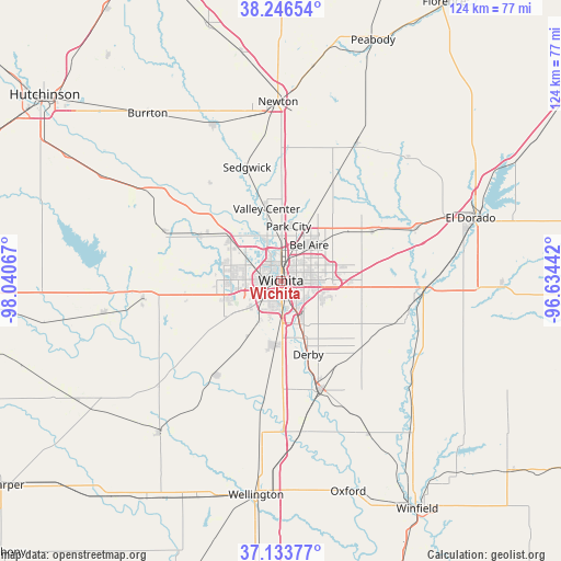
Wichita GPS coordinates[2]
37° 41' 32.064" North, 97° 20' 15.144" West
| Map corner | latitude | longitude |
|---|---|---|
| Upper-left | 38.24654°, | -98.04067° |
| Center: | 37.69224°, | -97.33754° |
| Lower-right: | 37.13377°, | -96.63442° |
| Map W x H: | 123.7×123.7 km | = 76.9×76.9mi |
| max Lat: | 71.29058° ⇑63.2% North |
| Wichita: | 37.69224° |
| min Lat: | ⇓36.8% South 19.06759° |
| min Long | Wichita | max Long |
| -171.73463° | -97.33754° | -66.98998° |
| W 23.3%⇐ | ⇒76.7% E |
Elevation
Elevation of Wichita is 402 m = 1319 ft, and this is 107.2 m = 352 ft above average elevation for this country.
| Max E: |
3189 m = 10463 ft | 16.2% |
| Wichita | 402 m 1319 ft | |
| Avg. | 294.8 m = 967 ft | |
Min E: |
-60 m = -197 ft | 83.8% |
See also: Wichita elevation on elevation.city.
Geographical zone
Wichita is located in North temperate zone (between Tropic of Cancer and the Arctic Circle). Distance of this Northern Tropic circle is 1585.1 km =984.9 mi to South.| Distance of | km | miles | from Wichita |
|---|---|---|---|
| North Pole | 5816.1 | 3614 | to North |
| Arctic Circle | 3210.2 | 1994.7 | to North |
| Tropic Cancer | 1585.1 | 984.9 | to South |
| Equator | 4191 | 2604.2 | to South |


Nearby cities:
15 places around Wichita: (largest is in red/bold)
• Andover
17.9 km =11.1 mi,  82°
82°
• Bellaire
10 km =6.2 mi,  38°
38°
• Benton
22.8 km =14.2 mi,  61°
61°
• Colwich
20 km =12.4 mi,  298°
298°
• Derby
17.4 km =10.8 mi,  159°
159°
• Eastborough
6.5 km =4 mi,  94°
94°
• Goddard
21.2 km =13.2 mi,  260°
260°
• Haysville
14.3 km =8.9 mi,  185°
185°
• Kechi
12.6 km =7.8 mi,  23°
23°
• Maize
15 km =9.3 mi,  310°
310°
• McConnell AFB
9.8 km =6.1 mi,  134°
134°
• Mulvane
25.6 km =15.9 mi, 161°
• Park City
12.1 km =7.5 mi,  8°
8°
• Rose Hill
23.2 km =14.4 mi, 129°
• Valley Center
16.2 km =10.1 mi,  348°
348°
Sources, notices
• [Note1] Compared only with cities in United States existing in our database
• [Src1] Map data: © OpenStreetMap contributors (CC-BY-SA)
• [Src2] Other city data from geonames.org with taken over terms of usage.
• [Src3] Geographical zone / Annual Mean Temperature by Robert A. Rohde @ Wikipedia
