Eastborough geodata
Eastborough (Kansas) is a populated place; located in United States in America/Chicago (GMT-5) time zone. With population of 768 people, there are 18065 cities with bigger population in this country. Compared to other cities in United States, 63.3% of cities are located further ↑North; 76.5% of cities are located further →East and 85.1% of cities have lower elevation than Eastborough. Note1


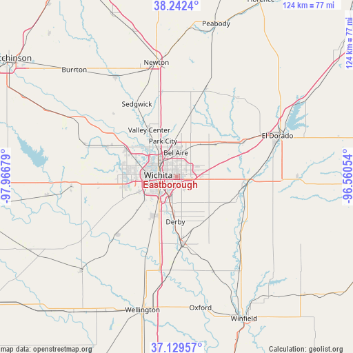
Eastborough GPS coordinates[2]
37° 41' 17.052" North, 97° 15' 49.176" West
| Map corner | latitude | longitude |
|---|---|---|
| Upper-left | 38.2424°, | -97.96679° |
| Center: | 37.68807°, | -97.26366° |
| Lower-right: | 37.12957°, | -96.56054° |
| Map W x H: | 123.7×123.7 km | = 76.9×76.9mi |
| max Lat: | 71.29058° ⇑63.3% North |
| Eastborough: | 37.68807° |
| min Lat: | ⇓36.7% South 19.06759° |
| min Long | Eastborough | max Long |
| -171.73463° | -97.26366° | -66.98998° |
| W 23.5%⇐ | ⇒76.5% E |
Elevation
Elevation of Eastborough is 425 m = 1394 ft, and this is 130.2 m = 427 ft above average elevation for this country.
| Max E: |
3189 m = 10463 ft | 14.9% |
| Eastborough | 425 m 1394 ft | |
| Avg. | 294.8 m = 967 ft | |
Min E: |
-60 m = -197 ft | 85.1% |
See also: United States elevation on elevation.city.
Geographical zone
Eastborough is located in North temperate zone (between Tropic of Cancer and the Arctic Circle). Distance of this Northern Tropic circle is 1584.6 km =984.6 mi to South.| Distance of | km | miles | from Eastborough |
|---|---|---|---|
| North Pole | 5816.5 | 3614.2 | to North |
| Arctic Circle | 3210.7 | 1995 | to North |
| Tropic Cancer | 1584.6 | 984.6 | to South |
| Equator | 4190.5 | 2603.9 | to South |


Nearby cities:
15 places around Eastborough: (largest is in red/bold)
• Andover
11.6 km =7.2 mi,  75°
75°
• Augusta
25.3 km =15.7 mi,  90°
90°
• Bellaire
8.3 km =5.2 mi,  357°
357°
• Benton
17.6 km =10.9 mi,  50°
50°
• Colwich
26 km =16.2 mi,  292°
292°
• Derby
15.9 km =9.9 mi,  181°
181°
• Haysville
15.8 km =9.8 mi,  209°
209°
• Kechi
12.1 km =7.5 mi,  353°
353°
• Maize
20.6 km =12.8 mi,  299°
299°
• McConnell AFB
6.5 km =4 mi, 176°
• Mulvane
23.8 km =14.8 mi, 175°
• Park City
13.3 km =8.3 mi,  338°
338°
• Rose Hill
18.3 km =11.4 mi,  141°
141°
• Valley Center
18.9 km =11.7 mi,  329°
329°
• Wichita
6.5 km =4 mi,  274°
274°
Sources, notices
• [Note1] Compared only with cities in United States existing in our database
• [Src1] Map data: © OpenStreetMap contributors (CC-BY-SA)
• [Src2] Other city data from geonames.org with taken over terms of usage.
• [Src3] Geographical zone / Annual Mean Temperature by Robert A. Rohde @ Wikipedia
