Benton geodata
Benton (Kansas) is a populated place; located in United States in America/Chicago (GMT-5) time zone. With population of 876 people, there are 17148 cities with bigger population in this country. Compared to other cities in United States, 62.7% of cities are located further ↑North; 76% of cities are located further →East and 84.9% of cities have lower elevation than Benton. Note1


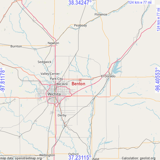
Benton GPS coordinates[2]
37° 47' 20.04" North, 97° 6' 31.14" West
| Map corner | latitude | longitude |
|---|---|---|
| Upper-left | 38.34247°, | -97.81178° |
| Center: | 37.7889°, | -97.10865° |
| Lower-right: | 37.23115°, | -96.40553° |
| Map W x H: | 123.6×123.6 km | = 76.8×76.8mi |
| max Lat: | 71.29058° ⇑62.7% North |
| Benton: | 37.7889° |
| min Lat: | ⇓37.3% South 19.06759° |
| min Long | Benton | max Long |
| -171.73463° | -97.10865° | -66.98998° |
| W 24%⇐ | ⇒76% E |
Elevation
Elevation of Benton is 422 m = 1385 ft, and this is 127.2 m = 417 ft above average elevation for this country.
| Max E: |
3189 m = 10463 ft | 15.1% |
| Benton | 422 m 1385 ft | |
| Avg. | 294.8 m = 967 ft | |
Min E: |
-60 m = -197 ft | 84.9% |
See also: United States elevation on elevation.city.
Geographical zone
Benton is located in North temperate zone (between Tropic of Cancer and the Arctic Circle). Distance of this Northern Tropic circle is 1595.8 km =991.6 mi to South.| Distance of | km | miles | from Benton |
|---|---|---|---|
| North Pole | 5805.3 | 3607.2 | to North |
| Arctic Circle | 3199.4 | 1988 | to North |
| Tropic Cancer | 1595.8 | 991.6 | to South |
| Equator | 4201.7 | 2610.8 | to South |


Nearby cities:
15 places around Benton: (largest is in red/bold)
• Andover
8.7 km =5.4 mi,  196°
196°
• Augusta
16.2 km =10.1 mi,  134°
134°
• Bellaire
14.2 km =8.8 mi,  258°
258°
• Derby
30.5 km =19 mi,  207°
207°
• Eastborough
17.6 km =10.9 mi,  230°
230°
• El Dorado
21.9 km =13.6 mi,  81°
81°
• Kechi
15 km =9.3 mi,  272°
272°
• Leon
30.7 km =19.1 mi,  110°
110°
• McConnell AFB
22 km =13.7 mi,  216°
216°
• Park City
18.5 km =11.5 mi, 273°
• Rose Hill
25.7 km =16 mi,  185°
185°
• Towanda
9.6 km =6 mi, 84°
• Valley Center
23.8 km =14.8 mi,  282°
282°
• Whitewater
19.8 km =12.3 mi,  350°
350°
• Wichita
22.8 km =14.2 mi,  241°
241°
Sources, notices
• [Note1] Compared only with cities in United States existing in our database
• [Src1] Map data: © OpenStreetMap contributors (CC-BY-SA)
• [Src2] Other city data from geonames.org with taken over terms of usage.
• [Src3] Geographical zone / Annual Mean Temperature by Robert A. Rohde @ Wikipedia
