Edwardsville geodata
Edwardsville (Kansas) is a populated place; located in United States in America/Chicago (GMT-5) time zone. With population of 4,390 people, there are 7762 cities with bigger population in this country. Compared to other cities in United States, 54.3% of cities are located further ↑North; 70.7% of cities are located further →East and 60.5% of cities have lower elevation than Edwardsville. Note1


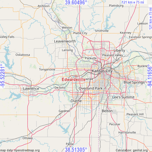
Edwardsville GPS coordinates[2]
39° 3' 40.032" North, 94° 49' 10.848" West
| Map corner | latitude | longitude |
|---|---|---|
| Upper-left | 39.60496°, | -95.52281° |
| Center: | 39.06112°, | -94.81968° |
| Lower-right: | 38.51305°, | -94.11656° |
| Map W x H: | 121.4×121.4 km | = 75.4×75.4mi |
| max Lat: | 71.29058° ⇑54.3% North |
| Edwardsville: | 39.06112° |
| min Lat: | ⇓45.7% South 19.06759° |
| min Long | Edwardsville | max Long |
| -171.73463° | -94.81968° | -66.98998° |
| W 29.3%⇐ | ⇒70.7% E |
Elevation
Elevation of Edwardsville is 242 m = 794 ft, and this is 52.8 m = 173 ft below average elevation for this country.
| Max E: |
3189 m = 10463 ft | 39.5% |
| Avg. | 294.8 m = 967 ft | |
| Edwardsville | 242 m = 794 ft | |
Min E: |
-60 m = -197 ft | 60.5% |
See also: United States elevation on elevation.city.
Geographical zone
Edwardsville is located in North temperate zone (between Tropic of Cancer and the Arctic Circle). Distance of this Northern Tropic circle is 1737.3 km =1079.5 mi to South.| Distance of | km | miles | from Edwardsville |
|---|---|---|---|
| North Pole | 5663.9 | 3519.4 | to North |
| Arctic Circle | 3058 | 1900.2 | to North |
| Tropic Cancer | 1737.3 | 1079.5 | to South |
| Equator | 4343.2 | 2698.7 | to South |


Nearby cities:
15 places around Edwardsville: (largest is in red/bold)
• Basehor
13.6 km =8.5 mi,  311°
311°
• Bonner Springs
5.5 km =3.4 mi,  268°
268°
• De Soto
15.8 km =9.8 mi,  234°
234°
• Fairway
16.8 km =10.4 mi,  104°
104°
• Highland
17 km =10.6 mi,  356°
356°
• Kansas City
17.6 km =10.9 mi,  70°
70°
• Lake Quivira
4.4 km =2.7 mi,  121°
121°
• Lenexa
14.1 km =8.8 mi,  148°
148°
• Merriam
11.7 km =7.3 mi,  110°
110°
• Mission
14.6 km =9.1 mi, 104°
• Overland Park
15.6 km =9.7 mi, 124°
• Prairie Village
17.8 km =11.1 mi, 115°
• Roeland Park
16.4 km =10.2 mi, 99°
• Shawnee
8.9 km =5.5 mi, 104°
• Westwood
17.7 km =11 mi, 97°
Sources, notices
• [Note1] Compared only with cities in United States existing in our database
• [Src1] Map data: © OpenStreetMap contributors (CC-BY-SA)
• [Src2] Other city data from geonames.org with taken over terms of usage.
• [Src3] Geographical zone / Annual Mean Temperature by Robert A. Rohde @ Wikipedia
