Lenexa geodata
Lenexa (Kansas) is a populated place; located in United States in America/Chicago (GMT-5) time zone. With population of 52,490 people, there are 893 cities with bigger population in this country. Compared to other cities in United States, 55.4% of cities are located further ↑North; 70.5% of cities are located further →East and 75.7% of cities have lower elevation than Lenexa. Note1


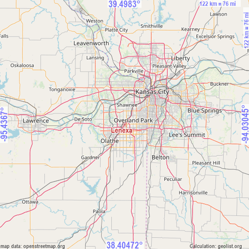
Lenexa GPS coordinates[2]
38° 57' 13.032" North, 94° 44' 0.852" West
| Map corner | latitude | longitude |
|---|---|---|
| Upper-left | 39.4983°, | -95.4367° |
| Center: | 38.95362°, | -94.73357° |
| Lower-right: | 38.40472°, | -94.03045° |
| Map W x H: | 121.6×121.6 km | = 75.6×75.6mi |
| max Lat: | 71.29058° ⇑55.4% North |
| Lenexa: | 38.95362° |
| min Lat: | ⇓44.6% South 19.06759° |
| min Long | Lenexa | max Long |
| -171.73463° | -94.73357° | -66.98998° |
| W 29.5%⇐ | ⇒70.5% E |
Elevation
Elevation of Lenexa is 318 m = 1043 ft, and this is 23.2 m = 76 ft above average elevation for this country.
| Max E: |
3189 m = 10463 ft | 24.3% |
| Lenexa | 318 m 1043 ft | |
| Avg. | 294.8 m = 967 ft | |
Min E: |
-60 m = -197 ft | 75.7% |
See also: Lenexa elevation on elevation.city.
Geographical zone
Lenexa is located in North temperate zone (between Tropic of Cancer and the Arctic Circle). Distance of this Northern Tropic circle is 1725.3 km =1072.1 mi to South.| Distance of | km | miles | from Lenexa |
|---|---|---|---|
| North Pole | 5675.8 | 3526.8 | to North |
| Arctic Circle | 3069.9 | 1907.5 | to North |
| Tropic Cancer | 1725.3 | 1072.1 | to South |
| Equator | 4331.2 | 2691.3 | to South |


Nearby cities:
15 places around Lenexa: (largest is in red/bold)
• Bonner Springs
17.5 km =10.9 mi,  312°
312°
• Edwardsville
14.1 km =8.8 mi,  328°
328°
• Fairway
11.6 km =7.2 mi,  49°
49°
• Lake Quivira
10.3 km =6.4 mi,  338°
338°
• Leawood
10.2 km =6.3 mi,  81°
81°
• Loch Lloyd
18 km =11.2 mi,  139°
139°
• Merriam
8.5 km =5.3 mi,  23°
23°
• Mission
10.6 km =6.6 mi,  39°
39°
• Mission Hills
12.4 km =7.7 mi, 54°
• Olathe
10.9 km =6.8 mi,  222°
222°
• Overland Park
6.3 km =3.9 mi,  59°
59°
• Prairie Village
9.6 km =6 mi, 63°
• Roeland Park
12.8 km =8 mi, 43°
• Shawnee
9.9 km =6.2 mi,  6°
6°
• Westwood
14 km =8.7 mi, 46°
Sources, notices
• [Note1] Compared only with cities in United States existing in our database
• [Src1] Map data: © OpenStreetMap contributors (CC-BY-SA)
• [Src2] Other city data from geonames.org with taken over terms of usage.
• [Src3] Geographical zone / Annual Mean Temperature by Robert A. Rohde @ Wikipedia
