Shawnee geodata
Shawnee (Kansas) is a populated place; located in United States in America/Chicago (GMT-5) time zone. With population of 65,046 people, there are 662 cities with bigger population in this country. Compared to other cities in United States, 54.4% of cities are located further ↑North; 70.4% of cities are located further →East and 77.1% of cities have lower elevation than Shawnee. Note1


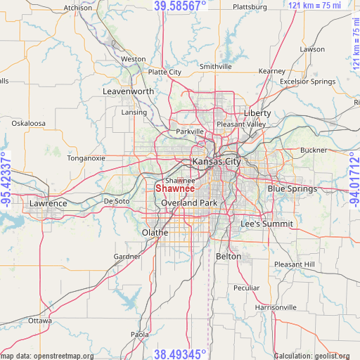
Shawnee GPS coordinates[2]
39° 2' 30.012" North, 94° 43' 12.864" West
| Map corner | latitude | longitude |
|---|---|---|
| Upper-left | 39.58567°, | -95.42337° |
| Center: | 39.04167°, | -94.72024° |
| Lower-right: | 38.49345°, | -94.01712° |
| Map W x H: | 121.4×121.4 km | = 75.4×75.4mi |
| max Lat: | 71.29058° ⇑54.4% North |
| Shawnee: | 39.04167° |
| min Lat: | ⇓45.6% South 19.06759° |
| min Long | Shawnee | max Long |
| -171.73463° | -94.72024° | -66.98998° |
| W 29.6%⇐ | ⇒70.4% E |
Elevation
Elevation of Shawnee is 328 m = 1076 ft, and this is 33.2 m = 109 ft above average elevation for this country.
| Max E: |
3189 m = 10463 ft | 22.9% |
| Shawnee | 328 m 1076 ft | |
| Avg. | 294.8 m = 967 ft | |
Min E: |
-60 m = -197 ft | 77.1% |
See also: Shawnee elevation on elevation.city.
Geographical zone
Shawnee is located in North temperate zone (between Tropic of Cancer and the Arctic Circle). Distance of this Northern Tropic circle is 1735.1 km =1078.1 mi to South.| Distance of | km | miles | from Shawnee |
|---|---|---|---|
| North Pole | 5666 | 3520.7 | to North |
| Arctic Circle | 3060.1 | 1901.5 | to North |
| Tropic Cancer | 1735.1 | 1078.1 | to South |
| Equator | 4341 | 2697.4 | to South |


Nearby cities:
15 places around Shawnee: (largest is in red/bold)
• Bonner Springs
14.2 km =8.8 mi,  278°
278°
• Edwardsville
8.9 km =5.5 mi, 284°
• Fairway
7.9 km =4.9 mi,  105°
105°
• Kansas City
11.4 km =7.1 mi,  44°
44°
• Kansas City
13.8 km =8.6 mi,  62°
62°
• Lake Quivira
4.9 km =3 mi,  268°
268°
• Leawood
12.2 km =7.6 mi,  133°
133°
• Lenexa
9.9 km =6.2 mi,  186°
186°
• Merriam
3.1 km =1.9 mi, 131°
• Mission
5.8 km =3.6 mi, 105°
• Mission Hills
9.3 km =5.8 mi, 106°
• Overland Park
7.9 km =4.9 mi,  147°
147°
• Prairie Village
9.3 km =5.8 mi, 126°
• Roeland Park
7.6 km =4.7 mi,  93°
93°
• Westwood
8.9 km =5.5 mi, 90°
Sources, notices
• [Note1] Compared only with cities in United States existing in our database
• [Src1] Map data: © OpenStreetMap contributors (CC-BY-SA)
• [Src2] Other city data from geonames.org with taken over terms of usage.
• [Src3] Geographical zone / Annual Mean Temperature by Robert A. Rohde @ Wikipedia
