Lansing geodata
Lansing (Kansas) is a populated place; located in United States in America/Chicago (GMT-5) time zone. With population of 11,767 people, there are 3952 cities with bigger population in this country. Compared to other cities in United States, 52.6% of cities are located further ↑North; 70.8% of cities are located further →East and 65.2% of cities have lower elevation than Lansing. Note1


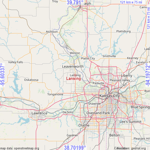
Lansing GPS coordinates[2]
39° 14' 54.996" North, 94° 54' 0.864" West
| Map corner | latitude | longitude |
|---|---|---|
| Upper-left | 39.791°, | -95.60337° |
| Center: | 39.24861°, | -94.90024° |
| Lower-right: | 38.70199°, | -94.19712° |
| Map W x H: | 121.1×121.1 km | = 75.2×75.2mi |
| max Lat: | 71.29058° ⇑52.6% North |
| Lansing: | 39.24861° |
| min Lat: | ⇓47.4% South 19.06759° |
| min Long | Lansing | max Long |
| -171.73463° | -94.90024° | -66.98998° |
| W 29.2%⇐ | ⇒70.8% E |
Elevation
Elevation of Lansing is 263 m = 863 ft, and this is 31.8 m = 104 ft below average elevation for this country.
| Max E: |
3189 m = 10463 ft | 34.8% |
| Avg. | 294.8 m = 967 ft | |
| Lansing | 263 m = 863 ft | |
Min E: |
-60 m = -197 ft | 65.2% |
See also: United States elevation on elevation.city.
Geographical zone
Lansing is located in North temperate zone (between Tropic of Cancer and the Arctic Circle). Distance of this Northern Tropic circle is 1758.1 km =1092.4 mi to South.| Distance of | km | miles | from Lansing |
|---|---|---|---|
| North Pole | 5643 | 3506.4 | to North |
| Arctic Circle | 3037.1 | 1887.2 | to North |
| Tropic Cancer | 1758.1 | 1092.4 | to South |
| Equator | 4364 | 2711.7 | to South |


Nearby cities:
15 places around Lansing: (largest is in red/bold)
• Basehor
12.3 km =7.6 mi,  195°
195°
• Bonner Springs
21.1 km =13.1 mi,  176°
176°
• Camden Point
26.5 km =16.5 mi,  30°
30°
• Edwardsville
22 km =13.7 mi,  161°
161°
• Highland
7.1 km =4.4 mi,  122°
122°
• Lake Quivira
25.5 km =15.8 mi, 155°
• Lake Waukomis
22.7 km =14.1 mi,  94°
94°
• Leavenworth
7.2 km =4.5 mi,  344°
344°
• McLouth
27.2 km =16.9 mi,  257°
257°
• Parkville
19.7 km =12.2 mi,  107°
107°
• Platte City
16.9 km =10.5 mi,  36°
36°
• Riverside
26 km =16.2 mi, 107°
• Tonganoxie
22.4 km =13.9 mi,  226°
226°
• Weatherby Lake
17.6 km =10.9 mi, 93°
• Weston
18.1 km =11.2 mi,  359°
359°
Sources, notices
• [Note1] Compared only with cities in United States existing in our database
• [Src1] Map data: © OpenStreetMap contributors (CC-BY-SA)
• [Src2] Other city data from geonames.org with taken over terms of usage.
• [Src3] Geographical zone / Annual Mean Temperature by Robert A. Rohde @ Wikipedia
