Tonganoxie geodata
Tonganoxie (Kansas) is a populated place; located in United States in America/Chicago (GMT-5) time zone. With population of 5,248 people, there are 6953 cities with bigger population in this country. Compared to other cities in United States, 53.8% of cities are located further ↑North; 71.3% of cities are located further →East and 67.8% of cities have lower elevation than Tonganoxie. Note1
Administrative division(s):
- Level 1: Kansas
- Level 2: Leavenworth County
- Level 3: Township of Tonganoxie


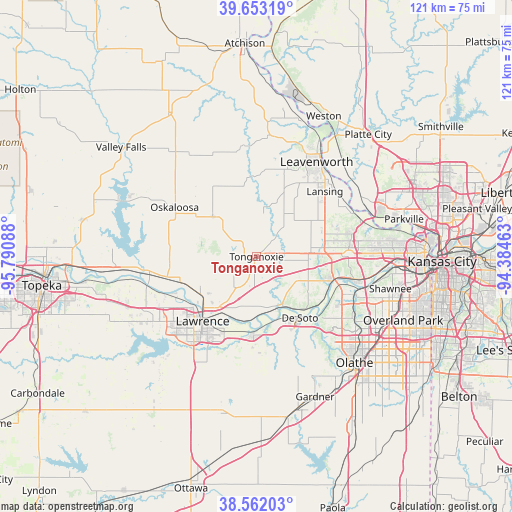
Tonganoxie GPS coordinates[2]
39° 6' 34.992" North, 95° 5' 15.9" West
| Map corner | latitude | longitude |
|---|---|---|
| Upper-left | 39.65319°, | -95.79088° |
| Center: | 39.10972°, | -95.08775° |
| Lower-right: | 38.56203°, | -94.38463° |
| Map W x H: | 121.3×121.3 km | = 75.4×75.4mi |
| max Lat: | 71.29058° ⇑53.8% North |
| Tonganoxie: | 39.10972° |
| min Lat: | ⇓46.2% South 19.06759° |
| min Long | Tonganoxie | max Long |
| -171.73463° | -95.08775° | -66.98998° |
| W 28.7%⇐ | ⇒71.3% E |
Elevation
Elevation of Tonganoxie is 275 m = 902 ft, and this is 19.8 m = 65 ft below average elevation for this country.
| Max E: |
3189 m = 10463 ft | 32.2% |
| Avg. | 294.8 m = 967 ft | |
| Tonganoxie | 275 m = 902 ft | |
Min E: |
-60 m = -197 ft | 67.8% |
See also: United States elevation on elevation.city.
Geographical zone
Tonganoxie is located in North temperate zone (between Tropic of Cancer and the Arctic Circle). Distance of this Northern Tropic circle is 1742.7 km =1082.9 mi to South.| Distance of | km | miles | from Tonganoxie |
|---|---|---|---|
| North Pole | 5658.5 | 3516 | to North |
| Arctic Circle | 3052.6 | 1896.8 | to North |
| Tropic Cancer | 1742.7 | 1082.9 | to South |
| Equator | 4348.6 | 2702.1 | to South |


Nearby cities:
15 places around Tonganoxie: (largest is in red/bold)
• Basehor
13.3 km =8.3 mi,  74°
74°
• Bonner Springs
18.5 km =11.5 mi,  107°
107°
• De Soto
17.8 km =11.1 mi,  144°
144°
• Edwardsville
23.8 km =14.8 mi,  103°
103°
• Eudora
18.5 km =11.5 mi,  182°
182°
• Highland
25 km =15.5 mi,  62°
62°
• Lake Quivira
27.9 km =17.3 mi, 106°
• Lansing
22.4 km =13.9 mi,  46°
46°
• Lawrence
19.9 km =12.4 mi,  219°
219°
• Leavenworth
26.5 km =16.5 mi,  32°
32°
• Lecompton
27.5 km =17.1 mi,  254°
254°
• McLouth
14.1 km =8.8 mi,  312°
312°
• Oskaloosa
22.7 km =14.1 mi,  301°
301°
• Perry
26.6 km =16.5 mi,  261°
261°
• Winchester
28.2 km =17.5 mi,  326°
326°
Sources, notices
• [Note1] Compared only with cities in United States existing in our database
• [Src1] Map data: © OpenStreetMap contributors (CC-BY-SA)
• [Src2] Other city data from geonames.org with taken over terms of usage.
• [Src3] Geographical zone / Annual Mean Temperature by Robert A. Rohde @ Wikipedia
