Maple Hill geodata
Maple Hill (Kansas) is a populated place; located in United States in America/Chicago (GMT-5) time zone. With population of 621 people, there are 19457 cities with bigger population in this country. Compared to other cities in United States, 54% of cities are located further ↑North; 73.5% of cities are located further →East and 73.1% of cities have lower elevation than Maple Hill. Note1
Administrative division(s):
- Level 1: Kansas
- Level 2: Wabaunsee County
- Level 3: Township of Maple Hill


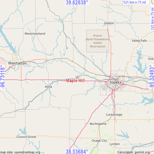
Maple Hill GPS coordinates[2]
39° 5' 4.992" North, 96° 1' 40.98" West
| Map corner | latitude | longitude |
|---|---|---|
| Upper-left | 39.62838°, | -96.73118° |
| Center: | 39.08472°, | -96.02805° |
| Lower-right: | 38.53684°, | -95.32493° |
| Map W x H: | 121.4×121.4 km | = 75.4×75.4mi |
| max Lat: | 71.29058° ⇑54% North |
| Maple Hill: | 39.08472° |
| min Lat: | ⇓46% South 19.06759° |
| min Long | Maple Hill | max Long |
| -171.73463° | -96.02805° | -66.98998° |
| W 26.5%⇐ | ⇒73.5% E |
Elevation
Elevation of Maple Hill is 302 m = 991 ft, and this is 7.2 m = 24 ft above average elevation for this country.
| Max E: |
3189 m = 10463 ft | 26.9% |
| Maple Hill | 302 m 991 ft | |
| Avg. | 294.8 m = 967 ft | |
Min E: |
-60 m = -197 ft | 73.1% |
See also: United States elevation on elevation.city.
Geographical zone
Maple Hill is located in North temperate zone (between Tropic of Cancer and the Arctic Circle). Distance of this Northern Tropic circle is 1739.9 km =1081.1 mi to South.| Distance of | km | miles | from Maple Hill |
|---|---|---|---|
| North Pole | 5661.2 | 3517.7 | to North |
| Arctic Circle | 3055.4 | 1898.5 | to North |
| Tropic Cancer | 1739.9 | 1081.1 | to South |
| Equator | 4345.8 | 2700.4 | to South |


Nearby cities:
15 places around Maple Hill: (largest is in red/bold)
• Alma
23.8 km =14.8 mi,  251°
251°
• Auburn
27 km =16.8 mi,  137°
137°
• Burlingame
40.4 km =25.1 mi,  155°
155°
• Carbondale
41.6 km =25.8 mi, 135°
• Eskridge
26.1 km =16.2 mi,  195°
195°
• Hoyt
33.1 km =20.6 mi,  56°
56°
• Meriden
41.2 km =25.6 mi,  73°
73°
• Onaga
46.6 km =29 mi,  344°
344°
• Rossville
8.7 km =5.4 mi,  49°
49°
• Saint George
35.8 km =22.2 mi,  289°
289°
• Saint Marys
12.7 km =7.9 mi, 343°
• Scranton
42 km =26.1 mi, 143°
• Silver Lake
14.8 km =9.2 mi,  81°
81°
• Topeka
30.5 km =19 mi,  97°
97°
• Wamego
27.2 km =16.9 mi,  298°
298°
Sources, notices
• [Note1] Compared only with cities in United States existing in our database
• [Src1] Map data: © OpenStreetMap contributors (CC-BY-SA)
• [Src2] Other city data from geonames.org with taken over terms of usage.
• [Src3] Geographical zone / Annual Mean Temperature by Robert A. Rohde @ Wikipedia
