Carbondale geodata
Carbondale (Kansas) is a populated place; located in United States in America/Chicago (GMT-5) time zone. With population of 1,396 people, there are 14129 cities with bigger population in this country. Compared to other cities in United States, 56.4% of cities are located further ↑North; 72.8% of cities are located further →East and 79.2% of cities have lower elevation than Carbondale. Note1


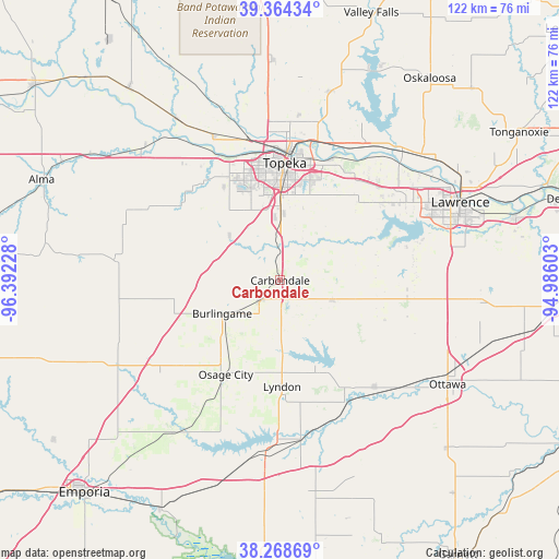
Carbondale GPS coordinates[2]
38° 49' 7.032" North, 95° 41' 20.94" West
| Map corner | latitude | longitude |
|---|---|---|
| Upper-left | 39.36434°, | -96.39228° |
| Center: | 38.81862°, | -95.68915° |
| Lower-right: | 38.26869°, | -94.98603° |
| Map W x H: | 121.8×121.8 km | = 75.7×75.7mi |
| max Lat: | 71.29058° ⇑56.4% North |
| Carbondale: | 38.81862° |
| min Lat: | ⇓43.6% South 19.06759° |
| min Long | Carbondale | max Long |
| -171.73463° | -95.68915° | -66.98998° |
| W 27.2%⇐ | ⇒72.8% E |
Elevation
Elevation of Carbondale is 346 m = 1135 ft, and this is 51.2 m = 168 ft above average elevation for this country.
| Max E: |
3189 m = 10463 ft | 20.8% |
| Carbondale | 346 m 1135 ft | |
| Avg. | 294.8 m = 967 ft | |
Min E: |
-60 m = -197 ft | 79.2% |
See also: United States elevation on elevation.city.
Geographical zone
Carbondale is located in North temperate zone (between Tropic of Cancer and the Arctic Circle). Distance of this Northern Tropic circle is 1710.3 km =1062.7 mi to South.| Distance of | km | miles | from Carbondale |
|---|---|---|---|
| North Pole | 5690.8 | 3536.1 | to North |
| Arctic Circle | 3084.9 | 1916.9 | to North |
| Tropic Cancer | 1710.3 | 1062.7 | to South |
| Equator | 4316.2 | 2682 | to South |


Nearby cities:
15 places around Carbondale: (largest is in red/bold)
• Auburn
14.7 km =9.1 mi,  311°
311°
• Burlingame
14.5 km =9 mi,  240°
240°
• Eskridge
36.7 km =22.8 mi,  277°
277°
• Lecompton
35.8 km =22.2 mi,  45°
45°
• Lyndon
23.2 km =14.4 mi,  178°
178°
• Maple Hill
41.6 km =25.8 mi,  315°
315°
• Osage City
23.7 km =14.7 mi,  209°
209°
• Overbrook
12.2 km =7.6 mi,  110°
110°
• Perry
38.4 km =23.9 mi,  41°
41°
• Pomona
31.2 km =19.4 mi,  138°
138°
• Pomona
32.1 km =19.9 mi, 140°
• Scranton
5.9 km =3.7 mi,  226°
226°
• Silver Lake
35 km =21.7 mi,  335°
335°
• Topeka
25.6 km =15.9 mi,  2°
2°
• Vassar
19.9 km =12.4 mi,  163°
163°
Sources, notices
• [Note1] Compared only with cities in United States existing in our database
• [Src1] Map data: © OpenStreetMap contributors (CC-BY-SA)
• [Src2] Other city data from geonames.org with taken over terms of usage.
• [Src3] Geographical zone / Annual Mean Temperature by Robert A. Rohde @ Wikipedia
