Topeka geodata
Topeka (Kansas) is a seat of a first-order administrative division; located in United States in America/Chicago (GMT-5) time zone. With population of 127,265 people, there are 245 cities with bigger population in this country. Compared to other cities in United States, 54.3% of cities are located further ↑North; 72.8% of cities are located further →East and 73.8% of cities have lower elevation than Topeka. Note1


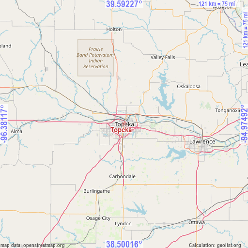
Topeka GPS coordinates[2]
39° 2' 53.988" North, 95° 40' 40.944" West
| Map corner | latitude | longitude |
|---|---|---|
| Upper-left | 39.59227°, | -96.38117° |
| Center: | 39.04833°, | -95.67804° |
| Lower-right: | 38.50016°, | -94.97492° |
| Map W x H: | 121.4×121.4 km | = 75.4×75.4mi |
| max Lat: | 71.29058° ⇑54.3% North |
| Topeka: | 39.04833° |
| min Lat: | ⇓45.7% South 19.06759° |
| min Long | Topeka | max Long |
| -171.73463° | -95.67804° | -66.98998° |
| W 27.2%⇐ | ⇒72.8% E |
Elevation
Elevation of Topeka is 306 m = 1004 ft, and this is 11.2 m = 37 ft above average elevation for this country.
| Max E: |
3189 m = 10463 ft | 26.2% |
| Topeka | 306 m 1004 ft | |
| Avg. | 294.8 m = 967 ft | |
Min E: |
-60 m = -197 ft | 73.8% |
See also: Topeka elevation on elevation.city.
Geographical zone
Topeka is located in North temperate zone (between Tropic of Cancer and the Arctic Circle). Distance of this Northern Tropic circle is 1735.8 km =1078.6 mi to South.| Distance of | km | miles | from Topeka |
|---|---|---|---|
| North Pole | 5665.3 | 3520.3 | to North |
| Arctic Circle | 3059.4 | 1901 | to North |
| Tropic Cancer | 1735.8 | 1078.6 | to South |
| Equator | 4341.8 | 2697.9 | to South |


Nearby cities:
15 places around Topeka: (largest is in red/bold)
• Auburn
19.8 km =12.3 mi,  217°
217°
• Burlingame
35.4 km =22 mi,  202°
202°
• Carbondale
25.6 km =15.9 mi,  182°
182°
• Hoyt
22.3 km =13.9 mi,  353°
353°
• Lecompton
24.5 km =15.2 mi,  91°
91°
• Maple Hill
30.5 km =19 mi,  277°
277°
• Meriden
18.2 km =11.3 mi,  30°
30°
• Oskaloosa
36.6 km =22.7 mi,  59°
59°
• Overbrook
31.6 km =19.6 mi,  160°
160°
• Ozawkie
27.5 km =17.1 mi,  41°
41°
• Perry
24.8 km =15.4 mi,  82°
82°
• Rossville
25.6 km =15.9 mi,  292°
292°
• Saint Marys
37.6 km =23.4 mi,  295°
295°
• Scranton
30.1 km =18.7 mi,  190°
190°
• Silver Lake
16.8 km =10.4 mi, 291°
Sources, notices
• [Note1] Compared only with cities in United States existing in our database
• [Src1] Map data: © OpenStreetMap contributors (CC-BY-SA)
• [Src2] Other city data from geonames.org with taken over terms of usage.
• [Src3] Geographical zone / Annual Mean Temperature by Robert A. Rohde @ Wikipedia
