Peabody geodata
Peabody (Kansas) is a populated place; located in United States in America/Chicago (GMT-5) time zone. With population of 1,144 people, there are 15417 cities with bigger population in this country. Compared to other cities in United States, 60.8% of cities are located further ↑North; 76% of cities are located further →East and 85.3% of cities have lower elevation than Peabody. Note1


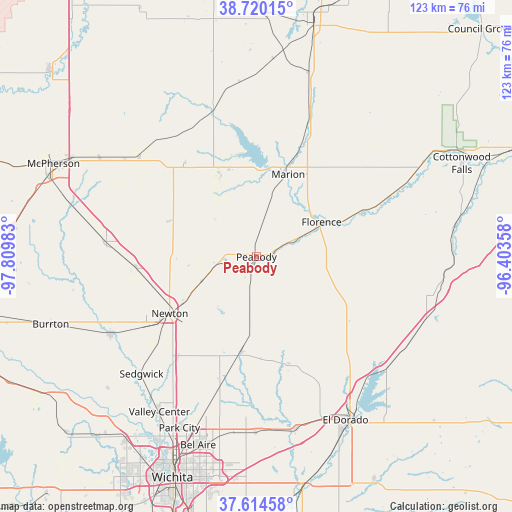
Peabody GPS coordinates[2]
38° 10' 10.056" North, 97° 6' 24.12" West
| Map corner | latitude | longitude |
|---|---|---|
| Upper-left | 38.72015°, | -97.80983° |
| Center: | 38.16946°, | -97.1067° |
| Lower-right: | 37.61458°, | -96.40358° |
| Map W x H: | 122.9×122.9 km | = 76.4×76.4mi |
| max Lat: | 71.29058° ⇑60.8% North |
| Peabody: | 38.16946° |
| min Lat: | ⇓39.2% South 19.06759° |
| min Long | Peabody | max Long |
| -171.73463° | -97.1067° | -66.98998° |
| W 24%⇐ | ⇒76% E |
Elevation
Elevation of Peabody is 430 m = 1411 ft, and this is 135.2 m = 444 ft above average elevation for this country.
| Max E: |
3189 m = 10463 ft | 14.7% |
| Peabody | 430 m 1411 ft | |
| Avg. | 294.8 m = 967 ft | |
Min E: |
-60 m = -197 ft | 85.3% |
See also: United States elevation on elevation.city.
Geographical zone
Peabody is located in North temperate zone (between Tropic of Cancer and the Arctic Circle). Distance of this Northern Tropic circle is 1638.1 km =1017.9 mi to South.| Distance of | km | miles | from Peabody |
|---|---|---|---|
| North Pole | 5763 | 3581 | to North |
| Arctic Circle | 3157.1 | 1961.7 | to North |
| Tropic Cancer | 1638.1 | 1017.9 | to South |
| Equator | 4244 | 2637.1 | to South |


Nearby cities:
15 places around Peabody: (largest is in red/bold)
• Benton
42.3 km =26.3 mi,  180°
180°
• Canton
37 km =23 mi,  310°
310°
• Goessel
22.8 km =14.2 mi,  292°
292°
• Halstead
39.8 km =24.7 mi,  242°
242°
• Hesston
28.6 km =17.8 mi,  263°
263°
• Hillsboro
22 km =13.7 mi,  337°
337°
• Kechi
44.2 km =27.5 mi,  200°
200°
• Marion
21.4 km =13.3 mi,  21°
21°
• Moundridge
36.2 km =22.5 mi,  275°
275°
• Newton
24.9 km =15.5 mi, 236°
• North Newton
23.5 km =14.6 mi, 242°
• Sedgwick
39.4 km =24.5 mi,  224°
224°
• Towanda
42.4 km =26.3 mi,  167°
167°
• Valley Center
43.9 km =27.3 mi,  212°
212°
• Whitewater
23 km =14.3 mi,  188°
188°
Sources, notices
• [Note1] Compared only with cities in United States existing in our database
• [Src1] Map data: © OpenStreetMap contributors (CC-BY-SA)
• [Src2] Other city data from geonames.org with taken over terms of usage.
• [Src3] Geographical zone / Annual Mean Temperature by Robert A. Rohde @ Wikipedia
