Whitewater geodata
Whitewater (Kansas) is a populated place; located in United States in America/Chicago (GMT-5) time zone. With population of 710 people, there are 18583 cities with bigger population in this country. Compared to other cities in United States, 61.8% of cities are located further ↑North; 76.2% of cities are located further →East and 85% of cities have lower elevation than Whitewater. Note1


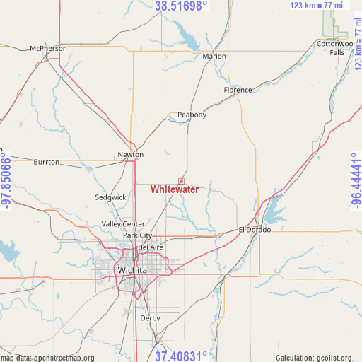
Whitewater GPS coordinates[2]
37° 57' 53.064" North, 97° 8' 51.108" West
| Map corner | latitude | longitude |
|---|---|---|
| Upper-left | 38.51698°, | -97.85066° |
| Center: | 37.96474°, | -97.14753° |
| Lower-right: | 37.40831°, | -96.44441° |
| Map W x H: | 123.3×123.3 km | = 76.6×76.6mi |
| max Lat: | 71.29058° ⇑61.8% North |
| Whitewater: | 37.96474° |
| min Lat: | ⇓38.2% South 19.06759° |
| min Long | Whitewater | max Long |
| -171.73463° | -97.14753° | -66.98998° |
| W 23.8%⇐ | ⇒76.2% E |
Elevation
Elevation of Whitewater is 424 m = 1391 ft, and this is 129.2 m = 424 ft above average elevation for this country.
| Max E: |
3189 m = 10463 ft | 15% |
| Whitewater | 424 m 1391 ft | |
| Avg. | 294.8 m = 967 ft | |
Min E: |
-60 m = -197 ft | 85% |
See also: United States elevation on elevation.city.
Geographical zone
Whitewater is located in North temperate zone (between Tropic of Cancer and the Arctic Circle). Distance of this Northern Tropic circle is 1615.4 km =1003.8 mi to South.| Distance of | km | miles | from Whitewater |
|---|---|---|---|
| North Pole | 5785.8 | 3595.1 | to North |
| Arctic Circle | 3179.9 | 1975.9 | to North |
| Tropic Cancer | 1615.4 | 1003.8 | to South |
| Equator | 4221.3 | 2623 | to South |


Nearby cities:
15 places around Whitewater: (largest is in red/bold)
• Andover
27.9 km =17.3 mi,  177°
177°
• Bellaire
24.8 km =15.4 mi,  205°
205°
• Benton
19.8 km =12.3 mi,  170°
170°
• Eastborough
32.4 km =20.1 mi,  198°
198°
• El Dorado
29.9 km =18.6 mi,  123°
123°
• Halstead
31.9 km =19.8 mi,  277°
277°
• Hesston
31.5 km =19.6 mi,  307°
307°
• Kechi
22.1 km =13.7 mi, 211°
• Newton
19.6 km =12.2 mi,  297°
297°
• North Newton
21.1 km =13.1 mi, 304°
• Park City
23.7 km =14.7 mi,  219°
219°
• Peabody
23 km =14.3 mi,  8°
8°
• Sedgwick
24.7 km =15.3 mi,  257°
257°
• Towanda
22.7 km =14.1 mi,  145°
145°
• Valley Center
24.5 km =15.2 mi,  233°
233°
Sources, notices
• [Note1] Compared only with cities in United States existing in our database
• [Src1] Map data: © OpenStreetMap contributors (CC-BY-SA)
• [Src2] Other city data from geonames.org with taken over terms of usage.
• [Src3] Geographical zone / Annual Mean Temperature by Robert A. Rohde @ Wikipedia
