Benton geodata
Benton (Kentucky) is a seat of a second-order administrative division; located in United States in America/Chicago (GMT-5) time zone. With population of 4,357 people, there are 7800 cities with bigger population in this country. Compared to other cities in United States, 66.7% of cities are located further ↑North; 54.3% of cities are located further →East and 64.2% of cities have higher elevation than Benton. Note1


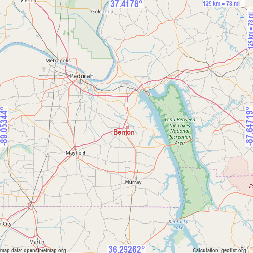
Benton GPS coordinates[2]
36° 51' 26.208" North, 88° 21' 1.116" West
| Map corner | latitude | longitude |
|---|---|---|
| Upper-left | 37.4178°, | -89.05344° |
| Center: | 36.85728°, | -88.35031° |
| Lower-right: | 36.29262°, | -87.64719° |
| Map W x H: | 125.1×125.1 km | = 77.7×77.7mi |
| max Lat: | 71.29058° ⇑66.7% North |
| Benton: | 36.85728° |
| min Lat: | ⇓33.3% South 19.06759° |
| min Long | Benton | max Long |
| -171.73463° | -88.35031° | -66.98998° |
| W 45.7%⇐ | ⇒54.3% E |
Elevation
Elevation of Benton is 132 m = 433 ft, and this is 162.8 m = 534 ft below average elevation for this country.
| Max E: |
3189 m = 10463 ft | 64.2% |
| Avg. | 294.8 m = 967 ft | |
| Benton | 132 m = 433 ft | |
Min E: |
-60 m = -197 ft | 35.8% |
See also: United States elevation on elevation.city.
Geographical zone
Benton is located in North temperate zone (between Tropic of Cancer and the Arctic Circle). Distance of this Northern Tropic circle is 1492.2 km =927.2 mi to South.| Distance of | km | miles | from Benton |
|---|---|---|---|
| North Pole | 5908.9 | 3671.6 | to North |
| Arctic Circle | 3303 | 2052.4 | to North |
| Tropic Cancer | 1492.2 | 927.2 | to South |
| Equator | 4098.1 | 2546.4 | to South |


Nearby cities:
15 places around Benton: (largest is in red/bold)
• Brookport
38.7 km =24 mi,  319°
319°
• Calvert City
19.6 km =12.2 mi,  0°
0°
• Eddyville
35.7 km =22.2 mi,  42°
42°
• Farley
28.6 km =17.8 mi, 317°
• Hardin
11.4 km =7.1 mi,  154°
154°
• Hendron
32 km =19.9 mi,  309°
309°
• Kuttawa
29.6 km =18.4 mi, 40°
• Ledbetter
24 km =14.9 mi,  331°
331°
• Massac
38.2 km =23.7 mi,  297°
297°
• Mayfield
28.6 km =17.8 mi,  243°
243°
• Murray
27.6 km =17.1 mi,  173°
173°
• Paducah
33.5 km =20.8 mi, 318°
• Reidland
24 km =14.9 mi, 317°
• Smithland
31.7 km =19.7 mi,  351°
351°
• Symsonia
16.6 km =10.3 mi,  294°
294°
Sources, notices
• [Note1] Compared only with cities in United States existing in our database
• [Src1] Map data: © OpenStreetMap contributors (CC-BY-SA)
• [Src2] Other city data from geonames.org with taken over terms of usage.
• [Src3] Geographical zone / Annual Mean Temperature by Robert A. Rohde @ Wikipedia
